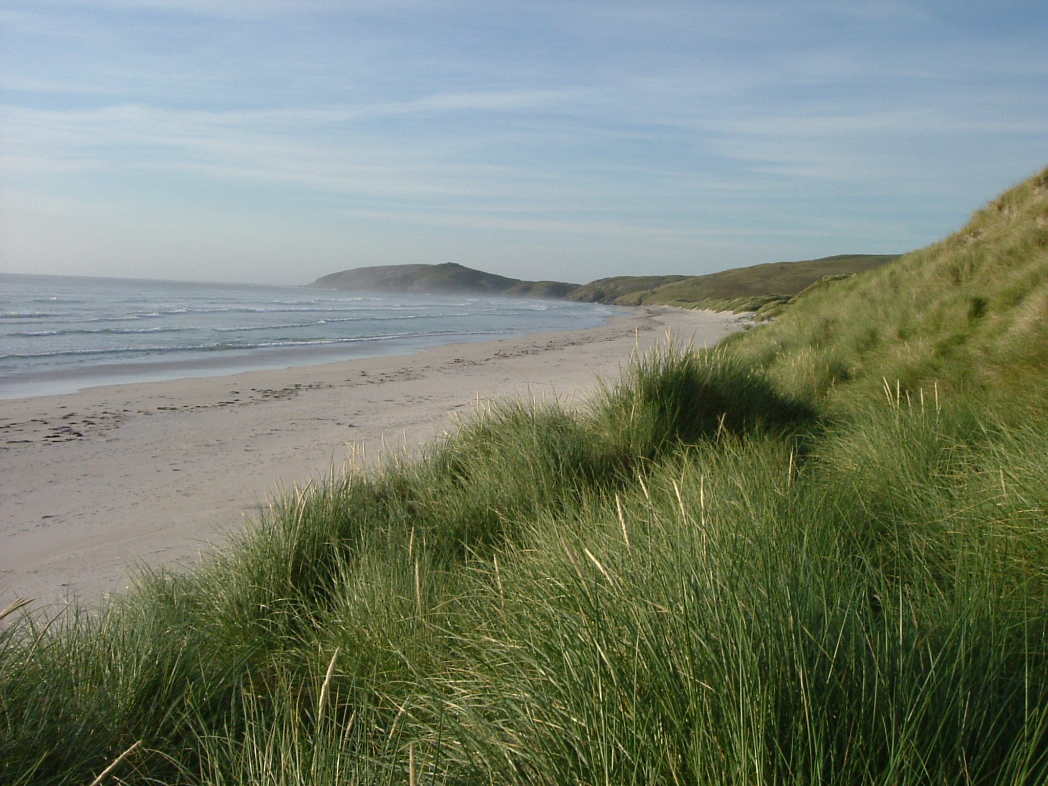
Sign In

My Timeline

GuRoute

Discover Your World

Share your Experiences

Record your Life


Top Attractions in Scotland

Glasgow

Glasgow is the largest city in Scotland, and the third largest in the United Kingdom (after London and Birmingham). Greater Glasgow had a population of 1,199,629 at the 2001 census. At the 2011 census, it had a population density of 8,790/sq mi (3,390/km2), the highest of any Scottish city. It is situated on the River Clyde in the country's West Central Lowlands. Inhabitants of the city are referred to as Glaswegians. Glasgow grew from a small rural settlement on the River Clyde to become the largest seaport in Britain. Expanding from the medieval bishopric and royal burgh, and the later establishment of the University of Glasgow in the 15th century, it became a major centre of the Scottish Enlightenment in the 18th century. From the 18th century the city also grew as one of Great Britain's main hubs of transatlantic trade with North America and the West Indies. With the onset of the Industrial Revolution, the population and economy of Glasgow and the surrounding region expanded rapidly to become one of the world's pre-eminent centres of chemicals, textiles and engineering; most notably in the shipbuilding and marine engineering industry, which produced many innovative and famous vessels. Glasgow was the "Second City of the British Empire" for much of the Victorian era and Edwardian period, although many cities argue the title was theirs. In the late 19th and early 20th centuries Glasgow grew in population, eventually reaching a peak of 1,128,473 in 1939. In the 1960s, comprehensive urban renewal projects resulting in large-scale relocation of people to new towns and peripheral suburbs, followed by successive boundary changes, have reduced the current population of the City of Glasgow council area to 593,245, with 2,199,629 people living in the Greater Glasgow urban area. The entire region surrounding the conurbation covers about 2.3 million people, 41% of Scotland's population. Glasgow hosted the 2014 Commonwealth Games. In other sports, Glasgow is also well known for the football rivalry of the Old Firm between Celtic and Rangers.

Lewis and Harris

Lewis and Harris in the Outer Hebrides make up the largest island in Scotland. The island is the third largest in the British Isles, after Great Britain and Ireland. The northern part of the island is called Lewis, the southern is Harris and both are frequently referred to as if they were separate islands. The boundary between Lewis and Harris is where the island narrows between Loch Resort on the west and Loch Seaforth on the east (north of the more obvious narrowing of the island at Tarbert). The island does not have a common name in either English or Scottish Gaelic and is referred to as 'Lewis and Harris', 'Lewis with Harris', 'Harris with Lewis' etc. Rarely used is the collective name of the Long Island (Scottish Gaelic: an t-Eilean Fada), although this is normally applied to the entire Outer Hebrides. Most of Harris is very hilly, with more than thirty peaks above 1,000 ft (300 m) high; the highest peak, Clisham, is a Corbett. It has an area of 841 square miles (2,178 km2) – slightly under one per cent of the area of Great Britain. It is 24 miles (39 km) from the nearest point of the mainland, from which it is separated by the Minch. Lewis is comparatively flat, save in the south-east, where Ben More reaches 1,874 ft (571 m), and in the south-west, where Mealasbhal 1,885 ft (575 m) is the highest point. Until 1975, Lewis belonged to the county of Ross and Cromarty and Harris to Inverness-shire. The entire island group now belongs to Comhairle nan Eilean Siar, the Western Isles Council.

Cairngorms National Park

The Cairngorms National Park (Scottish Gaelic Pàirc Nàiseanta a' Mhonaidh Ruaidh) is a national park in north east Scotland, established in 2003. It was the second of two national parks established by the Scottish Parliament, after Loch Lomond and the Trossachs National Park, set up in 2002. The park covers the Cairngorms range of mountains, and surrounding hills. Already the largest national park in the British Isles, in 2010 it expanded into Perth and Kinross. The Cairngorms National Park covers an area of 4,528 km2 (1,748 sq mi) in Aberdeenshire, Moray, Highland, Angus and Perth and Kinross Regions. The Cairngorm Mountains are a spectacular landscape, similar in appearance to the Hardangervidda National Park of Norway in having a large upland plateau. While the Hardengervidda National Park is recognised as a Category 2 national park under the IUCN categories (no activity that has a lasting impact on the natural environment is permitted) the Cairngorm National Park is a Category 5 protected landscape (sustainable development area) that has farmed and managed landscapes in which tourism is encouraged. Aviemore is a busy and popular holiday destination. The Highland Wildlife Park and Dalwhinnie distillery also lie within the National Park. Before the National Park was established in 2003, Scottish Natural Heritage conducted a consultation exercise, considering the boundary and the powers and structure of the new park authority. One option presented for the area included Tomatin, Blair Atholl, Aboyne and Glen Shee, making the park twice as big as the Lake District National Park. The area finally chosen was smaller than expected, but still the largest in Britain. It involved the boundary areas of Carrbridge, Laggan, Dalwhinnie, Grantown-on-Spey and Ballater. Many groups and local communities felt that a large area of highland Perth and Kinross should form part of the park and carried out a sustained campaign. On 13 March 2008 Michael Russell announced that the National Park would be extended to take in Blair Atholl and Spittal of Glenshee. There was also controversy surrounding the construction of the funicular Cairngorm Mountain Railway on Cairn Gorm, a scheme supported by the new National Park Authority. Supporters of the scheme claimed that it would bring in valuable tourist income, whilst opponents argued that such a development was unsuitable for a protected area. To reduce erosion, the railway operates a "closed scheme" and only allows skiers (in season) out of the upper Ptarmigan station. On 4 October 2010 the Park extended into Highland Perthshire and Glenshee.

Edinburgh

Edinburgh is the capital city of Scotland, located in Lothian on the southern shore of the Firth of Forth. It is the second most populous city in Scotland and the seventh most populous in the United Kingdom. The mid-year population estimate for 2014 is 492,680. Edinburgh lies at the heart of a Functional Urban Area with a population in 2011 of 834,648. The Edinburgh city region has a population of 1,330,480. Recognised as the capital of Scotland since at least the 15th century, Edinburgh is home to the Scottish Parliament and the seat of the monarchy in Scotland. The city is also the annual venue of the General Assembly of the Church of Scotland and home to national institutions such as the National Museum of Scotland, the National Library of Scotland and the Scottish National Gallery. It is the largest financial centre in the UK after London. The city has long been known as a centre of education, particularly in the fields of medicine, Scots law, the sciences and engineering. The University of Edinburgh, founded in 1582 and now one of four in the city, was placed 17th in the QS World University Rankings in 2013 and 2014. The city is also famous for the Edinburgh International Festival and the Fringe, the latter being the largest annual international arts festival in the world. The citys historical and cultural attractions have made it the second most popular tourist destination in the United Kingdom after London, attracting over one million overseas visitors each year . Historic sites in Edinburgh include Edinburgh Castle, Holyrood Palace, the churches of St. Giles, Greyfriars and the Canongate, and the extensive Georgian New Town, built in the 18th century. Edinburghs Old Town and New Town together are listed as a UNESCO World Heritage Site, which has been managed by Edinburgh World Heritage since 1999.

Aberdeen

Aberdeen is Scotland's third most populous city, one of Scotland's 32 local government council areas and the United Kingdom's 37th most populous built-up area, with an official population estimate of 228,990. Nicknames include the Granite City, the Grey City and the Silver City with the Golden Sands. During the mid-18th to mid-20th centuries, Aberdeen's buildings incorporated locally quarried grey granite, which can sparkle like silver because of its high mica content. Since the discovery of North Sea oil in the 1970s, other nicknames have been the Oil Capital of Europe or the Energy Capital of Europe. The area around Aberdeen has been settled since at least 8,000 years ago, when prehistoric villages lay around the mouths of the rivers Dee and Don. The city has a long, sandy coastline. Aberdeen received Royal Burgh status from David I of Scotland , transforming the city economically. The city's two universities, the University of Aberdeen, founded in 1495, and Robert Gordon University, which was awarded university status in 1992, make Aberdeen the educational centre of the north-east. The traditional industries of fishing, paper-making, shipbuilding, and textiles have been overtaken by the oil industry and Aberdeen's seaport. Aberdeen Heliport is one of the busiest commercial heliports in the world and the seaport is the largest in the north-east of Scotland. Aberdeen has won the Britain in Bloom competition a record-breaking ten times, and hosts the Aberdeen International Youth Festival, a major international event which attracts up to 1000 of the most talented young performing arts companies. In 2012, Mercer named Aberdeen the 56th most liveable city in the World, as well as the fourth most liveable city in Britain. In 2012, HSBC named Aberdeen as a leading business hub and one of eight 'super cities' spearheading the UK's economy, marking it as the only city in Scotland to receive this accolade.

Islay

Islay is the southernmost island of the Inner Hebrides of Scotland. Known as "The Queen of the Hebrides", it lies in Argyll just south west of Jura and around 40 kilometres north of the Irish coast. The island's capital is Bowmore where the distinctive round Kilarrow Parish Church and a distillery are located. Port Ellen is the main port. Islay is the fifth-largest Scottish island and the seventh-largest island surrounding Great Britain, with a total area of almost 620 square kilometres . There is ample evidence of the prehistoric settlement of Islay and the first written reference may have come in the 1st century AD. The island had become part of the Gaelic Kingdom of Dál Riata during the Early Middle Ages before being absorbed into the Norse Kingdom of the Isles. The later medieval period marked a "cultural high point" with the transfer of the Hebrides to the Kingdom of Scotland and the emergence of the Clan Donald Lordship of the Isles, originally centred at Finlaggan. During the 17th century the Clan Donald star waned, but improvements to agriculture and transport led to a rising population, which peaked in the mid-19th century. This was followed by substantial forced displacements and declining resident numbers. Today, it has over 3,000 inhabitants and the main commercial activities are agriculture, malt whisky distillation and tourism. The island has a long history of religious observance and Scottish Gaelic is spoken by about a quarter of the population. Its landscapes have been celebrated through various art forms and there is a growing interest in renewable energy. Islay is home to many bird species such as the wintering populations of Greenland white-fronted and barnacle goose, and is a popular destination throughout the year for birdwatchers. The climate is mild and ameliorated by the Gulf Stream. Islay is 40 kilometres long from north to south and 24 kilometres broad. The east coast is rugged and mountainous, rising steeply from the Sound of Islay, the highest peak being Beinn Bheigier, which is a Marilyn at 1,612 feet . The western peninsulas are separated from the main bulk of the island by the waters of Loch Indaal to the south and Loch Gruinart to the north. The fertile and windswept southwestern arm is called The Rinns, and Ardnave Point is a conspicuous promontory on the northwest coast. The south coast is sheltered from the prevailing winds and, as a result, relatively wooded. The fractal coast has numerous bays and sea lochs, including Loch an t-Sailein, Aros Bay and Claggain Bay. In the far southwest is a rocky and now largely uninhabited peninsula called The Oa, the closest point in the Hebrides to Ireland. The island's population is mainly centred around the villages of Bowmore and Port Ellen. Other smaller villages include Bridgend, Ballygrant, Port Charlotte, Portnahaven and Port Askaig. The rest of the island is sparsely populated and mainly agricultural. There are several small freshwater lochs in the interior including Loch Finlaggan, Loch Ballygrant, Loch Lossit and Loch Gorm, and numerous burns throughout the island, many of which bear the name "river" despite their small size. The most significant of these are the River Laggan which discharges into the sea at the north end of Laggan Bay, and the River Sorn which, draining Loch Finlaggan, enters the head of Loch Indaal at Bridgend. There are numerous small uninhabited islands around the coasts, the largest of which are Eilean Mhic Coinnich and Orsay off the Rinns, Nave Island on the northwest coast, Am Fraoch Eilean in the Sound of Islay, and Texa off the south coast.

Shetland

Shetland, also called the Shetland Islands, is a subarctic archipelago of Scotland that lies north-east of the island of Great Britain and forms part of the United Kingdom. The islands lie some 80 km to the northeast of Orkney and 280 km southeast of the Faroe Islands and form part of the division between the Atlantic Ocean to the west and the North Sea to the east. The total area is 1,466 km2 and the population totalled 23,210 in 2012. Comprising the Shetland constituency of the Scottish Parliament, Shetland is also one of the 32 council areas of Scotland; the islands administrative centre and only burgh is Lerwick. The largest island, known simply as "Mainland", has an area of 967 km2, making it the third-largest Scottish island and the fifth-largest of the British Isles. There are an additional 15 inhabited islands. The archipelago has an oceanic climate, a complex geology, a rugged coastline and many low, rolling hills. Humans have lived there since the Mesolithic period, and the earliest written references to the islands date back to Roman times. The early historic period was dominated by Scandinavian influences, especially Norway, and the islands did not become part of Scotland until the 15th century. When Shetland became part of the Kingdom of Great Britain in 1707, trade with northern Europe decreased. Fishing has continued to be an important aspect of the economy up to the present day. The discovery of North Sea oil in the 1970s significantly boosted Shetland incomes, employment and public sector revenues. The local way of life reflects the joint Norse and Scottish heritage including the Up Helly Aa fire festival, and a strong musical tradition, especially the traditional fiddle style. The islands have produced a variety of writers of prose and poetry, many of whom use the local Shetlandic dialect. There are numerous areas set aside to protect the local fauna and flora, including a number of important seabird nesting sites. The Shetland pony and Shetland Sheepdog are two well-known Shetland animal breeds. The islands motto, which appears on the Councils coat of arms, is Með lögum skal land byggja. This Icelandic phrase is taken from the Danish 1241 Basic Law: Jyske Lov, and is also mentioned in Njáls saga and means "By law shall land be built".

Falkirk

Falkirk is a town in the Central Lowlands of Scotland, historically within the county of Stirlingshire. It lies in the Forth Valley, 23.3 miles north-west of Edinburgh and 20.5 miles north-east of Glasgow. Falkirk had a resident population of 32,422 at the 2001 census. The population of the town had risen to 34,570 according to a 2008 estimate, making it the 20th most populous settlement in Scotland. Falkirk is the main town and administrative centre of the Falkirk council area, which has an overall population of 156,800 and inholds the nearby towns of Grangemouth, Bo'ness, Denny, Larbert and Stenhousemuir. The town lies at the junction of the Forth and Clyde Canal and the Union Canal, a location which proved key to the growth of Falkirk as a centre of heavy industry during the Industrial Revolution. In the 18th and 19th centuries Falkirk was at the centre of the iron and steel industry, underpinned by the Carron Company in the nearby village of Carron. The company was responsible for making carronades for the Royal Navy and also later many pillar boxes. In the last 50 years heavy industry has waned, and the economy of the town relies increasingly on retail and tourism. Despite this, Falkirk remains the home of many international companies like Alexander Dennis, the largest bus production company in the United Kingdom. Falkirk has a long association with the publishing industry. The company now known as Johnston Press was established in the town in 1846. The company, now based in Edinburgh, produces the Falkirk Herald, the largest selling weekly newspaper in Scotland. Attractions in and around Falkirk include the Falkirk Wheel, The Helix , Callendar House and Park and remnants of the Antonine Wall. In a 2011 poll conducted by STV, it was voted as Scotland's most beautiful town, ahead of Perth and Stirling in 2nd and 3rd place respectively.

Dundee

Dundee , officially the City of Dundee, is Scotland's fourth largest city and the 51st most populous built-up area in the United Kingdom. At the 2011 census, Dundee had a population density of 8,541.8/sq mi , the second highest of any Scottish city. The mid-year population estimate for 2014 is 148,260. It lies within the eastern central Lowlands on the north bank of the Firth of Tay, which feeds into the North Sea. Under the name of Dundee City, it forms one of the 32 council areas used for local government in Scotland. The city developed into a burgh in medieval times, and expanded rapidly in the 19th century largely due to the jute industry. This, along with its other major industries gave Dundee its epithet as city of "jute, jam and journalism". Dundee's recorded population reached a peak of 182,204 at the 1971 census. Today, Dundee is promoted as 'One City, Many Discoveries' in honour of Dundee's history of scientific activities and of the RRS Discovery, Robert Falcon Scott's Antarctic exploration vessel, which was built in Dundee and is now berthed in the city harbour. Biomedical and technological industries have arrived since the 1980s, and the city now accounts for 10% of the United Kingdom's digital-entertainment industry. Dundee has two universities—the University of Dundee and the Abertay University. In 2014 Dundee was recognised by the United Nations as the UK's first UNESCO City of Design for its diverse contributions to fields including medical research, comics and video games. A £1 billion master plan to regenerate and to reconnect the Waterfront to the city centre which started in 2001 is expected to be completed within a 30-year period, with the Dundee Victoria & Albert Museum opening by 2018 at a cost of £80 million.

Barra

Barra is an island in the Outer Hebrides in Scotland. Barra is the second southernmost inhabited island of the Outer Hebrides after the adjacent island of Vatersay, to which it is connected by a causeway. In 2011 the population was 1,174, almost 100 higher than the 1,078 counted at the time of the 2001 census. According to the 2011 Census, there are 761 Gaelic speakers on Barra. The area of Barra is roughly 60 square kilometres , the main village being Castlebay . The west of the island has white sandy beaches backed by shell-sand, machair and the east has numerous rocky inlets. Kisimul Castle at Castlebay is located on a rock in the bay, so giving the village its name. A smaller castle can be found in the middle of Loch St Clare on the west side of the Island in Tangasdale. The highest elevation on the island is Heaval, halfway up which is located a prominent white marble statue of the Madonna and Child, called "Our Lady of the Sea", which was erected during the of 1954. The predominant faith on the island is Catholicism and the Catholic church dedicated to Our Lady of the Sea is immediately apparent to all who arrive into Castlebay. Other places of interest on the island include a ruined church and museum at Cille Bharra, a number of Iron Age brochs such as those at Dùn Chuidhir and An Dùn Bàn and a range of other Iron Age and later structures which have recently been excavated and recorded. The island's place name is derived from two elements: Barr and Old Norse ey . It is possible that Barr represents the Gaelic personal name Finnbarr. Other possibilities are that it instead represents the Old Norse elements berr or barr , or perhaps the Celtic element *barr . Barra once formed part of the Kingdom of the Isles. In the middle part of the twelfth century, this realm was partitioned between the Crovan dynasty and Clann Somhairle, and it is uncertain which family controlled the island during this period. In 1293, years after the collapse of the realm and its incorporation into the Kingdom of Scotland, the island formed part of the Sheriffdom of Skye, which could be evidence that it had indeed formed part of the territories previously controlled by the Crovan dynasty like other parts of the sheriffdom. By this period the island appears to have formed part of the extensive Clann Ruaidhrí lordship. Early in the reign of Robert I, King of Scotland, the island was included in the king's confirmation of Clann Ruaidhrí territories to Ruaidhrí Mac Ruaidhrí. Later in 1343, Barra is again recorded in a royal charter to Raghnall Mac Ruaidhrí. Following the latter's assassination in 1346, the Clann Ruaidhrí territories passed into the possession of Eóin Mac Domhnaill, and formed part of the Clann Domhnaill Lordship of the Isles. In 1427, Alexander, Lord of the Isles granted the island to Giolla Adhamhnáin Mac Neill, a member of Clan MacNeil. The clan held the island until 1838, when Roderick MacNeil, sold the island to Colonel Gordon of Cluny. Gordon expelled most of the inhabitants in order to make way for sheep farming. The displaced islanders variously went to the Scottish mainland, Australia, New Zealand, the United States of America and Canada. Barra was restored to MacNeil ownership in 1937 when the Barra estate, which encompassed most of the island, was bought by Robert Lister Macneil. In 2003, the ownership of the Barra Estate was passed by the owner, Ian Roderick Macneil, to the Scottish Government. The estate can be transferred to the inhabitants in the future, at their request. Macneil had previously transferred Kisimul Castle to Historic Scotland in 2000. In May 2007 Channel 4's Time Team came to the hamlet of Allasdale to investigate the exposed remains of Bronze Age burials and Iron Age roundhouses in sand dunes that had been previously uncovered by storms. The programme was broadcast on 20 January 2008. The Dualchas Heritage and Cultural Centre is located in Castlebay, next to Castlebay Community School. It has various exhibitions annually, and is open throughout the year. The 1949 Ealing Studios comedy Whisky Galore! was filmed on Barra. The film is based on the novel Whisky Galore by Sir Compton Mackenzie, itself a fictionalised telling of the story of the SS Politician, which ran aground with a cargo of some 50,000 cases of whisky on board in 1941. Mackenzie, who lived near the airport and died in 1972, is buried in a grave marked by a simple cross at Cille Bharra cemetery, which is situated a little way up the hillside overlooking Eoligarry jetty. The sequel movie Rockets Galore! was also filmed in and around the island. In the sitcom Dad's Army, Private Frazer claims to be from Barra, which he often describes as "a wild and lonely place". Barra was also featured in the 2006 Channel 5 documentary Extraordinary people: The Boy Who Lived Before, where a young boy named Cameron, who lived in Glasgow, claimed to have memories of a past life on the island. The island was the location for the fifth and sixth series of the BBC Two documentary An Island Parish. and is regularly featured in various television programmes on the new Gaelic channel BBC Alba. In 2008 the Barra RNLI Life Boat, Edna Windsor was featured on a series of stamps. The first class stamp shows the 17 metres Severn class lifeboat in action in the Sound of Berneray 20 kilometres south west of Barra in 3.5 metres swell with 30 kilometres per hour of wind. Barra hosts an annual half-marathon called the Barrathon, which is part of the Western Isles Half Marathon series. This is accompanied by a shorter fun-run for families, and younger children. A number of fund-raising events are held around this, including ceilidhs and dances. There is also an annual hill race, where participants run up Heaval before returning to Castlebay Square. The fastest recorded time, set in 1987, is 26.25 minutes. The Barra community holds an annual games on the island. The island golf club, Comunn Goilf Bharraidh, has a 9-hole course that is claimed to be the furthest west in the United Kingdom. However, this title may in fact be held by one of the courses near Enniskillen in Northern Ireland. Tourists can also go sea kayaking or power kiting, and ample opportunities are available for keen anglers. Pony trekking is also an option, on the rare, native Eriskay Ponies. Barra's tiny airport, near Northbay, uses the beach called An Tràigh Mhòr as a runway. Planes can only land and take off at low tide meaning that the timetable varies. Voted the world's most stunning landing spot, Barra's airport is the only airport in the world to have scheduled flights landing on a beach. The aircraft currently in operation on Barra is the de Havilland Canada DHC-6 Twin Otter, flown by Loganair on services to Glasgow. There are usually flights every day of the week in the summer. The beach is also a source of cockles. Ferries to Oban, Lochboisdale, Tiree and Eriskay are run by Caledonian MacBrayne. Castlebay is the main port from which ferries sail to Oban on the Scottish mainland, Tiree and Lochboisdale in South Uist. The mainland crossing takes about 5 hours. A vehicular ferry travels between Ardmore and Ceann a' Gharaidh in Eriskay . The crossing takes around 40 minutes. The fish factory, Barratlantic, in Northbay is a major contributor to the island's economy and the Hebridean Toffee Factory in Castlebay is one of the few manufacturers on Barra. Tourism provides the main income for the majority of islanders, the high season lasting from May to September. Thousands of people visit the island every year, the busiest times being during Fèis Bharraigh & BarraFest in July. In 2010 camping on the machair at the airport was banned due to erosion, this prompted crofters to provide areas on their crofts for visiting tourists. Boat trips to the neighbouring island of Mingulay are available during the summer season and island hopping plane trips are also available. There is a planned Distillery to be built in Borve, on the west side of the island. The Isle of Barra Distillery (trading as Uisge Betha nan Eilean Ltd) has now installed four Proven 6 kW wind turbines next to the reservoir Loch Uisge which originally supplied the drinking water to Castlebay. It is proposed that as much of the necessary resources to produce the whisky should come from the Barra or the surrounding islands, with only the bare minimum necessary being imported from outside the island's economy.

St. Andrews

St Andrewsis a former royal burgh on the east coast of Fife in Scotland, 10 miles southeast of Dundee and 30 miles northeast of Edimburgh. The town is home to the University of St Andrews, the third oldest university in the English-speaking world and the oldest in Scotland. The University is an integral part of the burgh, and during term time students make up approximately one third of the town's population. St Andrews has a population of 16,680, making it the fifth largest settlement in Fife. The town is named after Saint Andrew the Apostle. There has been an important church in St Andrews since at least the 8th century, and a bishopric since at least the 11th century. The settlement grew to the west of St Andrews cathedral with the southern side of the Scores to the north and the Kinness burn to the south. The burgh soon became the ecclesiastical capital of Scotland, a position which was held until the Scottish Reformation. The famous cathedral, the largest in Scotland, now lies in ruins. St Andrews is also known worldwide as the "home of golf". This is in part because the Royal and Ancient Golf Club, founded in 1754, exercises legislative authority over the game worldwide (except in the United States and Mexico), and also because the famous links is the most frequent venue for The Open Championship, the oldest of golf's four major championships. Visitors travel to St Andrews in great numbers for several courses ranked amongst the finest in the world, as well as for the sandy beaches. The Martyrs Memorial, erected to the honour of Patrick Hamilton, George Wishart, and other martyrs of the Reformation epoch, stands at the west end of the Scores on a cliff overlooking the sea.

Inverness

Inverness is a city in the Scottish Highlands. It is the administrative centre for the Highland council area, and is regarded as the capital of the Highlands of Scotland. Inverness lies near two important battle sites: the 11th-century battle of Blàr nam Fèinne against Norway which took place on The Aird and the 18th-century Battle of Culloden which took place on Culloden Moor. It is the northernmost city in the United Kingdom and lies within the Great Glen at its north-eastern extremity where the River Ness enters the Moray Firth. At the latest, a settlement was established by the 6th century with the first royal charter being granted by Dabíd mac Maíl Choluim in the 12th century. The Gaelic king Mac Bethad Mac Findláich whose 11th-century murder of King Duncan was immortalised in Shakespeare's play Macbeth, held a castle within the city where he ruled as Mormaer of Moray and Ross. The population of greater Inverness grew from an estimated population of 51,610 in 2003 to 62,470 at the time of the 2011 Census. Inverness is one of Europe's fastest growing cities, with a third of the Highland population living in or around the city and is ranked fifth out of 189 British cities for its quality of life, the highest of any Scottish city. In the recent past, Inverness has experienced rapid economic growth between 1998 and 2008, Inverness and the rest of the central Highlands showed the largest growth of average economic productivity per person in Scotland and the second greatest growth in the United Kingdom as a whole, with an increase of 86%. Inverness is twinned with one German city, Augsburg and two French towns, La Baule and Saint-Valery-en-Caux. Inverness College is the main campus for the University of the Highlands and Islands. With around 8,500 students, Inverness College hosts around a quarter of all the University of the Highlands and Islands' students, and 30% of those studying to degree level. In 2014, a survey by a property website described Inverness as the happiest place in Scotland and the second happiest in the UK. Inverness was again found to be the happiest place in Scotland by a new study conducted in 2015.

Edinburgh Castle

Edinburgh Castle is a historic fortress which dominates the skyline of the city of Edinburgh, Scotland from its position on the Castle Rock. Archaeologists have established human occupation of the rock since at least the Iron Age, although the nature of the early settlement is unclear. There has been a royal castle on the rock since at least the reign of David I in the 12th century, and the site continued to be a royal residence until the Union of the Crowns in 1603. From the 15th century the castles residential role declined, and by the 17th century it was principally used as military barracks with a large garrison. Its importance as a part of Scotlands national heritage was recognised increasingly from the early 19th century onwards, and various restoration programmes have been carried out over the past century and a half. As one of the most important strongholds in the Kingdom of Scotland, Edinburgh Castle was involved in many historical conflicts from the Wars of Scottish Independence in the 14th century to the Jacobite Rising of 1745. Research undertaken in 2014 identified 26 sieges in its 1100 year-old history, giving it a claim to having been "the most besieged place in Great Britain and one of the most attacked in the world". Few of the present buildings pre-date the Lang Siege of the 16th century, when the medieval defences were largely destroyed by artillery bombardment. The most notable exceptions are St Margarets Chapel from the early 12th century, which is regarded as the oldest building in Edinburgh, the Royal Palace and the early-16th-century Great Hall, although the interiors have been much altered from the mid-Victorian period onwards. The castle also houses the Scottish regalia, known as the Honours of Scotland and is the site of the Scottish National War Memorial and the National War Museum of Scotland. The British Army is still responsible for some parts of the castle, although its presence is now largely ceremonial and administrative. Some of the castle buildings house regimental museums which contribute to its presentation as a tourist attraction. The castle, in the care of Historic Scotland, is Scotlands most-visited paid tourist attraction, with over 1.4 million visitors in 2013. As the backdrop to the Edinburgh Military Tattoo during the annual Edinburgh International Festival the castle has become a recognisable symbol of Edinburgh and of Scotland and indeed, it is Edinburghs most frequently visited visitor attraction according to the Edinburgh Visitor Survey, more than 70% of leisure visitors to Edinburgh visited the castle.

Perth

Perth is a city in central Scotland, located on the banks of the River Tay. It is the administrative centre of Perth and Kinross council area and the historic county of Perthshire. According to the preliminary 2011 census results Perth, including its immediate suburbs, has a population of 50,000. Perth has been known as The Fair City since the publication of the story Fair Maid of Perth by Scottish writer Sir Walter Scott in 1828. During the later medieval period the city was also called St John's Toun or Saint Johnstoun by its inhabitants in reference to the main church dedicated to St John the Baptist. This name is preserved by the city's football team, St Johnstone F.C. The name Perth comes from a Pictish word for wood or copse. There has been a settlement at Perth since prehistoric times, on a natural mound raised slightly above the flood plain of the Tay, where the river could be crossed at low tide. The area surrounding the modern city is known to have been occupied since Mesolithic hunter-gatherers arrived more than 8000 years ago. Nearby Neolithic standing stones and circles also exist, dating from about 4000 BC, following the introduction of farming in the area. The presence of Scone Abbey, home of the Stone of Destiny where the King of Scots was crowned, enhanced the early importance of the city. Perth became known as a 'capital' of Scotland, due to the frequent residence of the royal court. Royal Burgh status was soon given to the city by King William the Lion in the early 12th century. The city became one of the richest burghs in the country, doing trade with France, the Low Countries and Baltic Countries for goods such as Spanish silk and French wine. The Scottish Reformation also played a big role in the city with the sacking of the Houses of the Greyfriars and Blackfriars, after a sermon given by John Knox in St John's Kirk in 1559. The Act of Settlement later brought about Jacobite uprisings. The city was occupied by Jacobite supporters on three occasions . The founding of Perth Academy in 1760 helped to bring major industries, such as linen, leather, bleach and whisky, to the city. Given its location, Perth was perfectly placed to become a key transport centre with the coming of the railways, and its first station was built in 1848. Today, Perth serves as a retail centre for the surrounding area. Following the decline of the whisky industry locally, the city's economy has now diversified to include insurance and banking. Due to its location, the city is often referred to as the 'Gateway to the Highlands'. The Australian metropolis Perth took its name from the Scottish city. Perth is also twinned with Aschaffenburg in the Bavaria state of Germany.

Jura

Jura is an island in the Inner Hebrides of Scotland, adjacent and to the north-east of Islay. Compared with its fertile and more populous neighbour, Jura is mountainous, bare and infertile, covered largely by vast areas of blanket bog, hence its small population. In a list of the islands of Scotland ranked by size, Jura comes eighth, whereas ranked by population it comes thirty-first. It is in the council area of Argyll and Bute. Evidence of settlements on Jura dating from the Mesolithic period was first uncovered by the English archaeologist John Mercer in the 1960s. There is evidence of Neolithic settlement at Poll a' Cheo in the southwest of the island. The modern name "Jura" dates from the Norse-Gael era and is from the Old Norse Dyrøy meaning "beast [wild animal] island". In the sixth century, it is believed that Jura may have been the location of Hinba, the island to which the Irish founder of the Christian Church in Scotland Saint Columba retreated for prayer and contemplation from the monastic community which he founded on Iona. The Viking occupation of the Hebrides began in the ninth century, and was formalised when sovereignty was secured in 1098. From this point, Norse rule continued until 1266, when the Hebrides, together with Kintyre and the Isle of Man, were ceded to Scotland in the Treaty of Perth. A key figure during the Norse period was the warlord Somerled, whose descendants, for around 150 years from the mid-fourteenth century, styled themselves Lords of the Isles. The Lordship of the Isles was dominated by Clan Donald, whose seat was at Finlaggan on Islay. The Lordship came to an end in 1493, but Clan Donald continued to rule the southern part of Jura, through the MacDonalds of Dunnyveg. The north of the island, however, was owned by this time by Clan Maclean, whose seat was at Aros Castle in Glengarrisdale. In 1647, this was to be the site of a notable battle between the Macleans and the Campbells of Craignish. For many years in the twentieth century, a human skull stood on a ledge in a nearby cave, and it was traditionally said to have been the remains of a Maclean who had been killed in this battle. The skull is no longer there, but the latest editions of Ordnance Survey maps still mark the location as 'Maclean's Skull Cave'. The demise of the Lords of the Isles at the end of the fifteenth century was shortly followed in 1506 by the Treaty of Camas an Staca, which removed MacDonald rights on Jura and gave them to the Campbells. Despite this, the sixteenth century was a period of skirmishing between the warring clans: McDonalds, Campbells, MacLeans and others. Then in 1607 the Campbells finally bought the island from the MacDonalds. This was the beginning of some three hundred years during which the island was ruled and largely owned by eleven successive Campbell lairds. The north of the island, however, remained in MacLean hands until 1737, when it was sold to Donald MacNeil of Colonsay. From the mid-eighteenth century, long before the notorious Highland Clearances of the nineteenth century, there were a number of waves of emigration from Jura. In 1767, fifty people left Jura for Canada, and from that point the population gradually shrank from over a thousand to its twentieth century level of just a few hundred. Mercer notes that although relatively few forced clearances were recorded as taking place on Jura, the emigrations were far from voluntary, and were the result of factors such as hunger and spiralling rents. During the first half of the twentieth century the Campbells gradually sold the island as a number of separate estates, and the Campbell connection with Jura ended in 1938 with the sale of Jura House and the Ardfin Estate. There are now seven estates on Jura, all in separate ownership, with six of the seven held by absentees: Ardfin, Inver, Jura Forest, Tarbert, Ruantallain, Ardlussa, and Barnhill. There is also a relatively small area owned by Forestry Commission Scotland. Barnhill was the home of British novelist George Orwell, who lived there intermittently from 1946 until his death in 1950, and who completed his novel Nineteen Eighty-Four while living there. Despite its isolation, Barnhill has in recent years become something of a shrine for his readers. The Ardfin Estate is situated at the southern tip of the island, between Feolin and Craighouse. For some seventy years from 1938, Ardfin belonged to the Riley-Smith family, brewers from Tadcaster in Yorkshire. In 2010 the estate was bought by Greg Coffey, an Australian hedge-fund manager. and since then the famous walled garden of Jura House, which had previously been a popular tourist attraction, has been closed to the public. Having also wound up the estate's farm, Mr Coffey then submitted proposals for the construction of a private 18-hole golf course on the estate, which is due to be completed in 2016. 
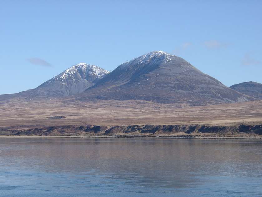
North of Ardfin, and flanking the Paps of Jura, lie the estates of Forest and Inver. Forest Estate, on the east side of the Paps, belongs to Samuel, 3rd Baron Vestey, Chairman of the food and farming business Vestey Group Ltd, and Master of the Horse of the Royal Household. Below the west slopes of the Paps lies Inver Estate, which belongs to Sir William Lithgow, Vice-Chairman of the Glasgow shipbuilding group Lithgows. North of the Corran River, and stretching as far as Loch Tarbert, is the Tarbert Estate. Prime Minister David Cameron has visited the estate on several occasions. It is sometimes reported that the 20,000-acre estate is "owned by his wife's stepfather Lord Astor" although the ownership of the Tarbert Estate is in the hands of Ginge Manor Estates Ltd based in Nassau in The Bahamas and there is "no means of verifying" who the beneficial absentee owners are. North of Loch Tarbert is Ruantallain, which was created when the northern half of the Tarbert Estate was sold off in 1984. It is owned by businessman Lindsay Bury, who is a former president of the influential wildlife charity Flora and Fauna International. The north of Jura belongs to two members of the Fletcher family. The owner of Ardlussa is Andrew Fletcher, who lives at Ardlussa House with his family - they are the only estate owners to be permanently resident on Jura. And at the northernmost tip of Jura, overlooking the famous Corryvreckan Whirlpool is the Barnhill Estate, which is owned by Jamie Fletcher. With an area of 36,692 hectares, or 142 square miles , and only 196 inhabitants recorded in the 2011 census, Jura is much less densely populated than neighbouring Islay and is one of the least densely populated islands of Scotland. Census records show that Jura's population peaked at 1,312 in 1831, and that, in common with many areas of western Scotland, the island's population declined steadily over the ensuing decades. However, there has been a small increase since 2001. During the same decade Scottish island populations as a whole grew by 4% to 103,702. Alongside the long-term decline in Jura's population has been a decline in the number of Gaelic speakers. The 1881 census reported that 86.6% spoke Gaelic. In 1961, for the first time less than half spoke the language and by 2001, this figure had dropped to 10.6%. The main settlement is the village of Craighouse on the east coast. Craighouse is home to the Jura distillery, producing Isle of Jura single malt whisky. The village is also home to the island's only hotel, shop and church. Between the northern tip of Jura and the island of Scarba lies the Gulf of Corryvreckan where a whirlpool makes passage dangerous at certain states of the tide. The southern part of the island, from Loch Tarbert southwards, is one of 40 National Scenic Areas in Scotland.

Isle of Skye

Skye or the Isle of Skye is the largest and most northerly major island in the Inner Hebrides of Scotland. The island's peninsulas radiate from a mountainous centre dominated by the Cuillins, the rocky slopes of which provide some of the most dramatic mountain scenery in the country. Although it has been suggested that the Gaelic Sgitheanach describes a winged shape there is no definitive agreement as to the name's origins. The island has been occupied since the Mesolithic period and its history includes a time of Norse rule and a long period of domination by Clan MacLeod and Clan Donald. The 18th-century Jacobite risings led to the breaking up of the clan system and subsequent Clearances that replaced entire communities with sheep farms, some of which also involved forced emigrations to distant lands. Resident numbers declined from over 20,000 in the early 19th century to just under 9,000 by the closing decade of the 20th century. Skye's population increased by 4 per cent between 1991 and 2001. About a third of the residents were Gaelic speakers in 2001, and although their numbers are in decline this aspect of island culture remains important. The main industries are tourism, agriculture, fishing and forestry. Skye is part of the Highland Council local government area. The island's largest settlement is Portree, known for its picturesque harbour. There are links to various nearby islands by ferry and, since 1995, to the mainland by a road bridge. The climate is mild, wet and windy. The abundant wildlife includes the golden eagle, red deer and Atlantic salmon. The local flora is dominated by heather moor, and there are nationally important invertebrate populations on the surrounding sea bed. Skye has provided the locations for various novels and feature films and is celebrated in poetry and song.

Stirling

Stirling is a city in central Scotland. The city is clustered around a large fortress and medieval old town. Stirling is the administrative centre for the Stirling council area, and is traditionally the county town of Stirlingshire. The city is located several miles to the west of the mouth of the River Forth. Historically it was strategically important as the "Gateway to the Highlands", with its position near the Highland Boundary Fault between the Scottish Lowlands and Highlands and has been described as the brooch which clasps the Highlands and the Lowlands together. Its historical position as the nearest crossing of the Forth to the river mouth meant that it attracted invaders. The beast of Stirling is the wolf, which it shares with Rome. According to legend, when Stirling was under attack from Viking invaders, a wolf howled, alerting the townspeople in time to save the town. Once the capital of Scotland, Stirling contains the Great Hall and the Renaissance Palace within Stirling Castle. Stirling also has its medieval parish church, the Church of the Holy Rude, where King James VI was crowned King of Scots on 29 July 1567. The Holy Rude still functions, with a service every Sunday. Stirling is a centre for local government, higher education, retail, and industry. In 2012, the population of the city was 45,750. The wider Stirling council area has a population of 89,850. The majority of the population is located in its southeast corner, in the City of Stirling and in the surrounding area. One of the principal royal strongholds of the Kingdom of Scotland, Stirling was created a Royal burgh by King David I in 1130, which it remained until 1975, when the burgh as an administrative unit was abolished. In 2002, as part of Queen Elizabeth II's Golden Jubilee, Stirling was granted city status.

Ayr

Ayr is a town and former Royal Burgh sitting along the west coast of Ayrshire in Scotland. It forms a part of the South Ayrshire Local Authority area, serving as the area's administrative centre. Historically, Ayr was the county town of Ayrshire until 1975. Ayr is currently the most populated settlement in Ayrshire and the South of Scotland. It is the 13th most populous locality in Scotland. The town was established in 1205 and soon developed as the central market and port along the west coast of Scotland, becoming a prominent trading port to Ireland. Oliver Cormwell also established a Citadel along the south of the river Ayr, the ramparts of which remain visible to this day. As the birthplace of famous Scottish poet Robert Burns, the suburb of Alloway, in the south of the town, houses his former home and the Robert Burns Experience. Across the Victorian era coal and iron remained the central export of the town, with fishing and shipping also forming a significant sect of the local economy. Ayr later developed as a holiday resort, aspects of which remain the case today with the continued presence of a Butlins holiday park to the south of the town. The Gaiety Theatre in Ayr ran various shows across the late 20th century, attracting performers from across the United Kingdom, and despite its decline throughout the 2000s, it remains in operation today. Politically, Ayr has been more Conservative-voting than the remainder of Scotland, being represented by a Conservative MP continuously for nearly 100 years from 1906 until 1997. The town forms part of the first Conservative seat in the Scottish Parliament which has voted Conservative since 2000. The town is now marginally contested between the Conservatives, the Scottish National Party and the Labour Party. Ayr is one of the largest retail centres along the South of Scotland and was recognised as the second healthiest town centre in the United Kingdom by the Royal Society for Public Health. Ayr has hosted the Scottish Grand National horse-racing steeplechase annually since 1965. The town also acts as headquarters to the Ayr Advertiser and Ayrshire Post newspapers and the West FM radio station.

This attraction is located in

This is a private property. Please enjoy respectfully and do not disturb the occupants.

Edit Categories
Add Tours

This attraction is not part of any tours

Add Collections

This attraction is not part of any collections


Some of the attractions we imported from Wikipedia are not perfect. Send us an email detailing what's wrong and we'll look into fixing it.

GuRoute is all about Gurus sharing their local knowledge. If you feel up to fixing this problem yourself, why not adopt it. You will become the owner and can fix whatever problems you see.

We've copied a link to this attraction into your clipboard so that ou can paste it into an email or text message...

More Info...
You can add your friends to the visit yourself, or, send them a link and let them add themselves...

The visit will appear on both your timelines and on your Shared Timeline.

Click below and we'll email you a link that you can send on to friends or post on your group's Facebook page.

If your friends aren't members of GuRoute yet, this is a great way to get them started.
Recent
Recently used Collections will appear here...
Recent
Recently used tours will appear here...

Where is this?

GuRoute likes to place attractions inside other attractions. So, maybe it's in a city, or maybe it's inside a particular park in that city. Maybe your attraction is a huge park that spans half the county, or multiple counties.

Determining where this attraction is gives it context - if it's in a park, you'll be able to see it alongside all the other attractions in that park. And that helps define the park.

GuRoute will automatically calculate a parent region for this attraction. You can change it if there is something more appropriate.

This attraction is currently located in .

Change

This attraction does not yet have any reviews

Please login to write a review...

Reviewed by
Record new Visit

Add this location to your timneline?

  • If there's an existing attraction open it and add it to your timeline...
  • If not, enter a title and we'll create a new attraction for your memories...
Create new Attraction

Create a new attraction at this location?

  • We rely on Gurus like you to share your local knowledge...
(Give a name for this location)


+
Add this to your timeline instead...

Imagine having a record of all the cool things you've done in your life!


Using our timeline you can keep track of everywhere you visit in your lifetime...

But, you'll need to sign in first...

Add contacts so that you can share your travels and record places that you visit together...

Family
Favorites
Family
Favorites

Profile TimeLine Our Visits Edit Accept Decline Invite

If you have any more friends that visited this place with you, feel free to add them to the visit. We'll write it to their timeline and once they confirm it, they too will have this memory for a lifetime.

If they're not already registered, you just need their name and email address and you can add them and we'll send them an invite on your behlaf.

Add a tour comment

Add some extra information for when this attraction is viewed as part of your tour...

Next Stop Instructions

Add some instructions for what to see/do on the way to the next stop...

Next Stop Instructions

Add some instructions for what to see/do on the way to the next stop...

If you're visiting an existing attraction, open it and add it to your timeline. If there is no attraction for the place you are visiting...

  • Click 'Add My Location' below
  • Or right-click on the map to mark a different location
  • Or long-press if you have a touch screen
You can even add locations while you're offline....
  • Load up the map when you're online and we'll keep track of your locaiton
  • You can add locations to your timeline
  • When you are online again we'll sync them with the cloud

We can't connect to the internet right now. The following attractions are saved locally and can be uploaded when you're online...

GuRoute would like to access your current location so that we can pin you on the map and show you nearby attractions

Add friends so that you can share your experiences with each other...

Add tour to What's Next?

Go...

Either for yourself or someone else...

  1. Do your trip research in GuRoute
    Add all the places that you think might be worthy of a visit into a trip-plan
  2. Add your trip-plan to your "What's Next" timeline
    (or a friend's "What's Next" timeline)
  3. When you're on vacation you'll have all your research at your fingertips
  4. Share your timline with your friends
    They can enjoy your vacation with you, seeing not only where you've been, but where you're going next...
  5. Add/remove attractions if things change

It also makes a great souvenir of your trip

Collections

Go...

Create a home page for a collection of attractions

  • Add an image and description to display on the homepage
  • Start adding content
    Add existing attractions to your collection or create new attractions of your own
  • Collections can be:
    • Public (Anyone can add attractions to your collection)
    • Shared (Only yourself and Gurus you nominate can add content)
    • Private (The collection will only be visible to yourself)

Uses

  • Local business or hotel
    Showcase local attractions that you endorse
  • Clubs
    Showcase attractions that members have created (eg. local historical society)
  • Special Interest
    If GuRoute does not have a category for your special interest you add your attractions to your own collection instead

Examples

Walking/Driving Tours

Go...

A guided tour where GuRoute will direct you from stop to stop and narrate a description of each attraction you arrive at

  • GuRoute uses your phone's GPS to guide you from stop to stop
  • GuRoute automatically detects when you arrive at the next tour-stop and narrates the description of the attraction (Chrome Only)
  • It then sends you on to the next stop

Tours are great to attract people to your town. Even places with no significant points of interest can be lots of fun when part of a tour


Cater tours to your Audience

  • Kid-friendly Tours
    • Focus on what will keep kids interested
    • Instead of parents having to drag their kids around they'll be struggling to keep up
    • Let the kids navigate and they'll get more fun out of finding that historical plaque than they ever would from reading it
  • Accessible tours
  • Short and long tours of the same location

What you need to do...

  1. Click 'Go...'
    Enter a title, description and location for the tour
  2. Add existing attractions OR create new ones and add them to the tour
  3. For existing attractions you can add more information specific to the theme of the tour
  4. You can also add instructions on what to do or see en-route to the next tour-stop
  5. Try out your tour and see how it works...

Mystery Tour

Go...

Create a Mystery Tour

Create a series of clues to show people around a city, neighborhood or whatever place you like...

  • GuRoute will show people clues to get them from attraction to attraction
  • When they reach each stop GuRoute will tell them about the place and give them the next clue
  • Take as long or as you like and explore each location at your leisure

Scavenger Hunt

Go...

Create a Scavenger Hunt

Create a series of questions that people have to answer. The answers can all be discovered by walking aroung the area, looking for clues.

  • How many beers are on tap at Michael Collin's Irish Bar?
  • What's the name of the oldest building on main streeet?
  • Show a picture of some public art and ask them what it is called
  • Clues can have numeric or multiple choice answers