Sign In

My Timeline

GuRoute

Discover Your World

Share your Experiences

Record your Life


Top Attractions in Cameroon

Lake Barombi Koto

Lake Barombi Koto, also known as Lake Barombi Kotto or Lake Barombi-ba-Kotto, is a small lake in the volcanic chain in the Southwest Region of Cameroon. It is a volcanic lake with a diameter of about 1.2 km . There is a small island in the middle, which is densely inhabited by the Barombi, a tribe of fishers. The Tung Nsuia and Tung Nsuria streams, each about 1-2 m wide and 0.3 m deep near their mouth, are the only inflows into the lake, and they dry out in dry season. Lake Barombi Koto often appears green-brown because it is rich in phytoplankton. Invertebrates, turtles and the aquatic frog Xenopus tropicalis are common in the lake, which is also an important sanctuary for birds. Seven fish species are known from the lake, including Barbus callipterus and a Clarias catfish, while the remaining all are cichlids: Coptodon kottae, Chromidotilapia guentheri, Hemichromis fasciatus, Pelmatolapia mariae and Sarotherodon galilaeus. Of these, C. guentheri is represented by the endemic subspecies loennbergi, while C. kottae is entirely endemic to this lake and the smaller Lake Mboandong. Both endemics are threatened by pollution and sedimentation from human activities, and "turning" of the lake's water because of deforestation of the surroundings (this may allow more wind, and the lake is stratified with oxygen-poor lower levels). They are potentially also threatened by large emissions of carbon dioxide from the lake's bottom (compare Lake Nyos). The nothobranchiids Aphyosemion bivittatum, Epiplatys sexfasciatus and Fundulopanchax oeseri, the poeciliid Procatopus similis, and Barbus callipterus are found in the Tung Nsuia and Tung Nsuria streams. Bulinus snails infested with Schistosoma, which causes the disease bilharzia in humans, are present in the lake.

Rhumsiki

Rhumsiki, also spelt Rumsiki and Roumsiki, is a village in the Far North Province of Cameroon. Rhumsiki is located in the Mandara Mountains 55 km from Mokolo and 3 km from the border with Nigeria. The village is similar to many others in northern Cameroon. The inhabitants, members of the Kapsiki ethnic group, live in small houses built from local stone and topped with thatched roofs; these homes are scattered throughout the village and surrounding valley. Nevertheless, Rhumsiki is one of Cameroon's most popular tourist attractions and "the most touristic place in northern Cameroon". The attraction is the surrounding scenery. Gwanfogbe, et al., describe it as "remarkable", Lonely Planet as "striking", Rough Guides as "breathtaking" and Bradt Guides as an "almost lunar landscape". Writer and explorer André Gide wrote that Rhumsiki's surroundings are "one of the most beautiful landscapes in the world." The spectacular effect is created by surrounding volcanic plugs (the remnants of long-dormant volcanoes), basalt outcroppings, and the Mandara Mountains. The largest of these rocks is Kapsiki Peak, a plug standing 1,224 m tall. Rhumsiki has adapted to the flow of tourists. Children in the village act as tour guides, showing visitors several pre-arranged attractions. Among these are craftspeople, such as blacksmiths, potters, spinners, and weavers; native dancers; and the féticheur, a fortune-teller who predicts the future based on a crab's manipulation of pieces of wood. Rhumsiki is now a standard item on most tourist itineraries, a fact of which the travel literature disapproves. Rough Guides describes Rhumsiki as "overrun" and "tainted by organized tourism", and Lonely Planet calls it "something of a tourist trap." The standard guided tour of the village leads The Rough Guide to doubt its authenticity: "The appeal of the visit is largely to get a taste of the 'real' Cameroon, and the built-in flaw is that the more people come, the more distorted and unreal life in the village becomes." The Rhumsiki 'plug' is very obviously phallic and both traditionally and in the modern world this has been one of the main features of Rhumsiki.

Mbam Djerem National Park

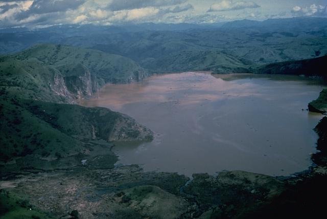
Across Cameroon, and its neighbours to east and west, lies a zone known as the Ecotone. This is the northern fringe of the Central African forests, where gallery forest tendrils reach out into the great savannahs of the north. The band of ecotone has, as a consequence, representatives of the flora and fauna of both forest and savannah. A protected area was created in January 2000 in this ecosystem in the centre of Cameroon, and named the Mbam Djerem National Park. It covers 4200 square kilometres, of which about half is lowland tropical forest, and half is Sudano-Guinean tree and woodland savannah, with a wide ecotone belt between the two. This straddling of two major vegetation zones gives Mbam Djerem probably the highest habitat diversity of all the protected areas in Cameroon. The new National Park boasts gallery forests, transitional forests and rainforests, different types of savannahs ranging from almost completely closed woodland through bush savannah, to open, seasonally flooded grasslands next to the major rivers one of which has a spectacular waterfall. Standing on any hilltop in the Park affords a view of ridge after ridge vanishing into the distance, some of them forested, some savannah, and all valleys clothed in a strip of gallery forest along the water’s edge.The Park is watered by the upper Sanaga basin: the main river of the Park is the Djerem, which becomes the Sanaga itself further south. This river is navigable throughout its length in the Park and allows access from the savannahs of the north into the heart of the forest. A dirt road runs along the western border of the Park, which was once the main road from the Cameroon coast to Chad, over a thousand kilometres away. In the colonial era, people who used to live in what is now the Park were relocated to this road. In the last few decades, the railway line that connects Garoua to Yaounde, which runs along the eastern side of the Park, has taken most of the freight and passengers away from this axis, and the young people who come from the villages that are along the old road are drifting to the cities. Human use of the area that is now declared Park is limited to seasonal grazing by Fulani herdsmen, fishing along the Djerem, and to a mixture of illegal commercial hunting (mostly for large animals such as buffalo, warthog, red river hog, and, occasionally, elephant) and local village hunting. There are no villages inside the Park, but it was known that there is some hunting, including larger animals such as buffalo, waterbuck, and kob, often destined for the bushmeat markets of the distant cities. Cattle herders also seasonally use the area, especially in the more open grasslands of the northern part of the Park. The railway line is much more frequented and is a major conduit for the bushmeat trade, funnelling wild animal meat from the centre of Cameroon down to the populous centres of Yaounde and Bertoua. Savannah –forest interface: the return of forest cover. So far, four years on (that was 2005), surveys have covered much of the Park and the major vegetation zones have been explored. The first survey took place in March 2000, and covered the eastern half of the Park. The survey team were navigating using the maps available from the Centre Geographique Nationale, which, although printed in 1976, were produced from aerial photographs taken in the 1950s and 1960s. The maps show most of the south of the Park to be savannah. However, when the team approached the centre of the Park, although the map showed that the habitat should be bush savanna, they found themselves walking through shady woodland. On closer inspection, all the trees were not only mostly the same species (Xylopia aethiopica), they were all about the same age. Mixed in among this forest were dying individuals of typical savannah trees and bushes (Hymenocardia acida, Piliostigma thonningii, Bridelia ferruginea … ). There was little grass on the forest floor. Older local people interviewed from the villages to the west of the Park remember the area from forty years ago as grassland and bush, with gallery forests along the rivers. Closed-canopy lowland forest was found much further to the east, near the Djerem River. The forests of Central Africa go through long cycles of expansion and reduction, linked with long-term climatic cycles. At the moment the forests are expanding- or they would if bushfire (almost always lit by people) did not burn back the edges every year. Left to itself, the forest is reclaiming the savannah lands. In fact, as people had moved away from the Mbam Djerem area to the cities, the regular burning and grazing of this ecosystem had diminished since the 1950s. Thus the forest has regenerated, and continues to do so. On the recent satellite image it is clear that about half of the Park is now forested, and the other half is still savannah. As a praecursor to management, the conservation potential of Mbam Djerem was assessed for large and small mammals, birds, habitats, and the degree of use by humans. Of particular interest was the status of the elephant population in the area, including any evidence of seasonal movements. The large mammal and bird surveys were carried out by WCS, helped by Deborah Pires who surveyed the bats and small mammals. The Birdlife Important Bird Area team also surveyed the northern part of the Park in 2000. Four major surveys were carried out, covering all four quarters of the Park. The fauna is very diverse. As in many Central African sites, large mammal abundance increases with increased distance from the road and the villages. True savannah species such as baboon Papio anubis and warthog Phacochoerus africanus occur literally within metres of species of true forest animals, including crowned guenon Cercopithecus pogonias and red river hog Potamochoerus porcus, which here are found right up to the edges of the savannah. All three species of pig occur in the Park (red river hog, warthog, and giant forest hog Hylochoerus meinertzhageni), and there are hippo Hippopotamus amphibius at several sites along the Djerem river (Fig. 6). In addition, there are species of forest-savannah mosaic habitats such as bushbuck Tragelaphus scriptus and yellowbacked duiker Cephalophus sylvicultor. Within a few hundred metres it is possible to see signs of Kob Kobus kob, waterbuck Kobus ellipsiprymnus, and forest buffalo Syncerus caffer nanus, and to hear putty-nosed monkeys Cercopithecus nictitans -a strange mixture of forest and savannah wildlife all at one site. Ungulate diversity is high: apart from those mentioned above there are bongo and sitatunga (Tragelaphus euryceros and T. scriptus), several species of duiker (confirmed are Blue, red-flanked, Grimm’s, Black-fronted). The presence of at least ten species of primate, including chimpanzees Pan troglodytes has been confirmed by the study teams either by direct observation of animals or their signs or by hearing their vocalisations, and local hunters suggested there could be still more. They described a tiny monkey that lived in large groups near rivers, which were talapoin. One of the most vulnerable animals in the Park is elephant. They occur in the south-centre of the Park but seem to be completely absent in the north (both east and west sides of the Park). Gorillas occur outside the Park, to the southeast, in the Lom-Pangar area (Fotso et al. 2002) but are not found in the Park. The area where they occur is now a National Park: Deng Deng National Park. The first bird list for Mbam et Djerem, a synthesis of the Fotso and Bobo/ Languy surveys, numbered 360 species, and, as for the mammal fauna, included both true savannah species such as Emberiza affinis, Lagonosticta rara, Lamprotornis chloropterus, Grafisia torquata, Nilaus afer, Anthoscopus parvulus and true forest species such as some of the hornbills Black and White Casqued Hornbill Ceratogymna subcylindricus, Black Casqued Hornbill Ceratogymna atrata, Red-billed Dwarf Hornbill Tockus camurus, and passerines such as Bleda syndactyla, Bleda eximia, Alethe diademata, Stiphrornis erythrothorax Criniger Calurus, Indicator maculatus (Fotso 2000). The Bamenda Apalis Apalis bamendae was discovered to be relatively widespread throughout the area (Bobo & Languy 2000 a,b; Fotso 2000) - this bird had previously thought to have been restricted to a small area in the Bamenda Highlands of Northwest Cameroon, two hundred kilometres to the west of Mbam Djerem. The Park has not only a wide diversity of habitats, flora and fauna, but also of seasonal extremes of temperature. In the dry season, bushfires reduce the grasses to ash. Rivers and swampy valleys dry up completely. This seasonality has important implications for the animals that require frequent water: they are obliged to remain near the larger rivers for several months at a time. Normally water is not a limiting factor for humid forest species, but the forest animals here may be on the edge of their physical limits. This information is well known by hunters, who use the grassy plains near the major rivers during the wet season; kob, buffalo and waterbuck are found here during this season, and hunters travel in from the railway line to transport meat out to the east. It is clear that the Mbam Djerem National Park contains a representative bloc of the habitat diversity that comprises the ecotone area of Cameroon and its neighbours. The large mammal fauna, now almost gone in West Africa, is still present, although threatened by commercial bushmeat (and some ivory) hunting. Local people in the area have few other activities that bring in money: profits on the small-scale agricultural products grown in the area are much lower than those gained by selling meat. The main methods of commercial hunting are thick wire snares aimed at the larger ungulates, and gun hunting, although small game hunting is carried out using thin wire snares near the villages (often outside the Park border). Conservation success will depend on reducing the levels of large mammal hunting in the area, and encouraging local people to see the wildlife of the Park as a potential for the future, not just today.

Bakossi Forest Reserve

The Bakossi Forest Reserve is a 5,517 square kilometres reserve within the Bakossi Mountains in Cameroon, home to many rare species of plants, animals and birds. The Forest Reserve in turn contains the Bakossi National Park, created by a decree in early 2008. The park covers 29,320 hectares , and was justified on the basis of preserving plant diversification. The Bakossi Mountains, which include Mount Kupe, cover in total about 230,000 square kilometres , with perhaps the largest area of cloud forest in West-Central Africa. They are part of a larger tract of forest that extends northward into the western foothills of the Bamboutos Mountains. The reserve was created in 1956. In 2000, the main section of the reserve was designated a protection forest. All logging was banned and Kupe became a "strict nature reserve". The local Bakossi people participated in delineating the boundaries. Between 2003 and 2007, the effectiveness of management in this and other parks improved greatly, although the local people were not well integrated into the system, and lacked education and awareness of environmental goals. The mountains have one of the healthiest remaining populations of the endangered drill, a primate related to the mandrill. The drill population in Bakossiland has been threatened by hunters in the area. Drills became extinct in the late 1970s in the Loum Forest Reserve, and may be extinct on Mount Mwanenguba. However, since 1994, on Mount Kupe the drill population has started to recover due to protection from the Bakossi traditional chiefs. Other primates are Preuss's monkey, red-eared guenon, greater spot-nosed monkey and several species of bush baby, collared mangabey, chimpanzee and Preuss's red colobus. Some of the species of chameleon are thought to be found only in the region. The area has many species of bird. On Mount Kupe alone, more than 329 species have been recorded. These include the Mount Kupe bushshrike, the endangered white-throated mountain babbler, and the vulnerable green-breasted bushshrike and grey-necked picathartes.

Lagdo Reservoir

Lagdo Reservoir is a lake located in the Northern Province of Cameroon. The lake covers an area of 586 km². It is located at 8°53′N 13°58′E. The Lagdo dam was built between 1977 and 1982 by a combination of engineers and Chinese workers, along with Cameroonian laborers. The company that managed the construction was the China International Water & Electric Corp. Today, international power company AES SONEL runs the hydroelectric dam. The dam is located 50 km south of the city of Garoua on the Benue River. Its construction was intended to supply electricity to the northern part of the country and allow the irrigation of 15 000 hectares of crops downstream. The dam is 308 m long, 40 m in height and 9 m thick. The dam is located within the Arrondissement de Lagdo in the Département de la Benoué in the North Province. In 2012, Water Released from the dam flooded areas around the dam including Adamawa State in Nigeria, the flooding resulted in over 10 deaths and loss of properties worth thousands of dollars. A bigger effect of the flooding is however at the lower Benue river region where more than 10,000 homes have been submerged for more than two weeks (since 13 September 2012). This has left more than 10000 hecters of farm land flooded and the streets of makurdi town occupied by crocodies amongst other dangerous creeping creatures. This is not the first time such an occurrence,but the government of Nigeria are still yet to find a solution. Viewed from space this lake resembles a small cat.

This attraction is located in

This is a private property. Please enjoy respectfully and do not disturb the occupants.

Edit Categories
Add Tours

This attraction is not part of any tours

Add Collections

This attraction is not part of any collections


Some of the attractions we imported from Wikipedia are not perfect. Send us an email detailing what's wrong and we'll look into fixing it.

GuRoute is all about Gurus sharing their local knowledge. If you feel up to fixing this problem yourself, why not adopt it. You will become the owner and can fix whatever problems you see.

We've copied a link to this attraction into your clipboard so that ou can paste it into an email or text message...

More Info...
You can add your friends to the visit yourself, or, send them a link and let them add themselves...

The visit will appear on both your timelines and on your Shared Timeline.

Click below and we'll email you a link that you can send on to friends or post on your group's Facebook page.

If your friends aren't members of GuRoute yet, this is a great way to get them started.
Recent
Recently used Collections will appear here...
Recent
Recently used tours will appear here...

Where is this?

GuRoute likes to place attractions inside other attractions. So, maybe it's in a city, or maybe it's inside a particular park in that city. Maybe your attraction is a huge park that spans half the county, or multiple counties.

Determining where this attraction is gives it context - if it's in a park, you'll be able to see it alongside all the other attractions in that park. And that helps define the park.

GuRoute will automatically calculate a parent region for this attraction. You can change it if there is something more appropriate.

This attraction is currently located in .

Change

This attraction does not yet have any reviews

Please login to write a review...

Reviewed by
Record new Visit

Add this location to your timneline?

  • If there's an existing attraction open it and add it to your timeline...
  • If not, enter a title and we'll create a new attraction for your memories...
Create new Attraction

Create a new attraction at this location?

  • We rely on Gurus like you to share your local knowledge...
(Give a name for this location)


+
Add this to your timeline instead...

Imagine having a record of all the cool things you've done in your life!


Using our timeline you can keep track of everywhere you visit in your lifetime...

But, you'll need to sign in first...

Add contacts so that you can share your travels and record places that you visit together...

Family
Favorites
Family
Favorites

Profile TimeLine Our Visits Edit Accept Decline Invite

If you have any more friends that visited this place with you, feel free to add them to the visit. We'll write it to their timeline and once they confirm it, they too will have this memory for a lifetime.

If they're not already registered, you just need their name and email address and you can add them and we'll send them an invite on your behlaf.

Add a tour comment

Add some extra information for when this attraction is viewed as part of your tour...

Next Stop Instructions

Add some instructions for what to see/do on the way to the next stop...

Next Stop Instructions

Add some instructions for what to see/do on the way to the next stop...

If you're visiting an existing attraction, open it and add it to your timeline. If there is no attraction for the place you are visiting...

  • Click 'Add My Location' below
  • Or right-click on the map to mark a different location
  • Or long-press if you have a touch screen
You can even add locations while you're offline....
  • Load up the map when you're online and we'll keep track of your locaiton
  • You can add locations to your timeline
  • When you are online again we'll sync them with the cloud

We can't connect to the internet right now. The following attractions are saved locally and can be uploaded when you're online...

GuRoute would like to access your current location so that we can pin you on the map and show you nearby attractions

Add friends so that you can share your experiences with each other...

Add tour to What's Next?

Go...

Either for yourself or someone else...

  1. Do your trip research in GuRoute
    Add all the places that you think might be worthy of a visit into a trip-plan
  2. Add your trip-plan to your "What's Next" timeline
    (or a friend's "What's Next" timeline)
  3. When you're on vacation you'll have all your research at your fingertips
  4. Share your timline with your friends
    They can enjoy your vacation with you, seeing not only where you've been, but where you're going next...
  5. Add/remove attractions if things change

It also makes a great souvenir of your trip

Collections

Go...

Create a home page for a collection of attractions

  • Add an image and description to display on the homepage
  • Start adding content
    Add existing attractions to your collection or create new attractions of your own
  • Collections can be:
    • Public (Anyone can add attractions to your collection)
    • Shared (Only yourself and Gurus you nominate can add content)
    • Private (The collection will only be visible to yourself)

Uses

  • Local business or hotel
    Showcase local attractions that you endorse
  • Clubs
    Showcase attractions that members have created (eg. local historical society)
  • Special Interest
    If GuRoute does not have a category for your special interest you add your attractions to your own collection instead

Examples

Walking/Driving Tours

Go...

A guided tour where GuRoute will direct you from stop to stop and narrate a description of each attraction you arrive at

  • GuRoute uses your phone's GPS to guide you from stop to stop
  • GuRoute automatically detects when you arrive at the next tour-stop and narrates the description of the attraction (Chrome Only)
  • It then sends you on to the next stop

Tours are great to attract people to your town. Even places with no significant points of interest can be lots of fun when part of a tour


Cater tours to your Audience

  • Kid-friendly Tours
    • Focus on what will keep kids interested
    • Instead of parents having to drag their kids around they'll be struggling to keep up
    • Let the kids navigate and they'll get more fun out of finding that historical plaque than they ever would from reading it
  • Accessible tours
  • Short and long tours of the same location

What you need to do...

  1. Click 'Go...'
    Enter a title, description and location for the tour
  2. Add existing attractions OR create new ones and add them to the tour
  3. For existing attractions you can add more information specific to the theme of the tour
  4. You can also add instructions on what to do or see en-route to the next tour-stop
  5. Try out your tour and see how it works...

Mystery Tour

Go...

Create a Mystery Tour

Create a series of clues to show people around a city, neighborhood or whatever place you like...

  • GuRoute will show people clues to get them from attraction to attraction
  • When they reach each stop GuRoute will tell them about the place and give them the next clue
  • Take as long or as you like and explore each location at your leisure

Scavenger Hunt

Go...

Create a Scavenger Hunt

Create a series of questions that people have to answer. The answers can all be discovered by walking aroung the area, looking for clues.

  • How many beers are on tap at Michael Collin's Irish Bar?
  • What's the name of the oldest building on main streeet?
  • Show a picture of some public art and ask them what it is called
  • Clues can have numeric or multiple choice answers