Sign In

My Timeline

GuRoute

Discover Your World

Share your Experiences

Record your Life


Top Attractions in Haiti

Navassa Island

Navassa Island is a small, uninhabited island in the Caribbean Sea. The island is subject of an ongoing territorial dispute and is claimed as an unorganized unincorporated territory of the United States, which administers it through the U.S. Fish and Wildlife Service; and Haiti which claimed sovereignty over Navassa since 1801 through its constitution, as the basis of its objection over the later 1850s' U.S. claim. 
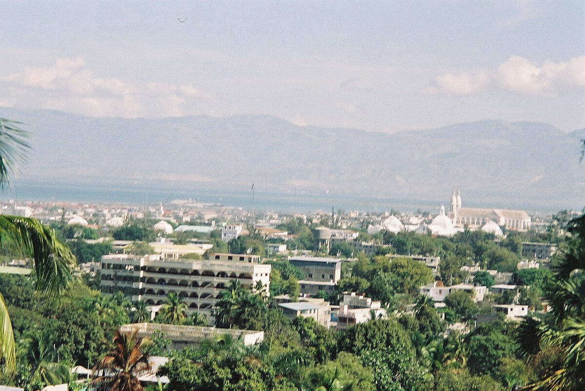
Navassa Island is about 2 square miles (5.2 km2) in area. It is located 35 miles (56 km) west of Haiti's southwest peninsula, 103 miles (166 km) south of the U.S. naval base at Guantanamo Bay, Cuba, and about one-quarter of the way from mainland Haiti to Jamaica in the Jamaica Channel. Navassa reaches an elevation of 250 feet (76 m) at Dunning Hill 110 yards (100 m) south of the lighthouse, Navassa Island Light. This location is 440 yards (400 m) from the southwestern coast or 655 yards (600 m) east of Lulu Bay. The terrain of Navassa Island consists mostly of exposed coral and limestone, the island being ringed by vertical white cliffs 30 to 50 feet (9.1 to 15.2 m) high, but with enough grassland to support goat herds. The island is covered in a forest of just four tree species: short-leaf fig (Ficus populnea var. brevifolia), pigeon plum (Coccoloba diversifolia), mastic (Sideroxylon foetidissimum), and poisonwood (Metopium brownei). Navassa Island's topography, ecology, and modern history are similar to that of Mona Island, a small limestone island located in the Mona Passage between Puerto Rico and the Dominican Republic, which were once centers of guano mining, and are nature reserves for the United States. Transient Haitian fishermen and others camp on the island but the island is otherwise uninhabited. It has no ports or harbors, only offshore anchorages, and its only natural resource is guano; economic activity consists of subsistence fishing and commercial trawling activities. There were eight species of native reptiles, all of which are believed to be, or to have been, endemic to Navassa Island: Celestus badius (an anguid lizard), Aristelliger cochranae (a gecko), Sphaerodactylus becki (a gecko), Anolis longiceps (an anole), Cyclura (cornuta) onchiopsis (a rock iguana), Leiocephalus eremitus (a curly-tailed lizard), Tropidophis bucculentus (a dwarf boa), and Typhlops sulcatus (a tiny snake). Of these the first four remain common with the last four likely extinct. Feral cats, dogs and pigs currently inhabit the island. 
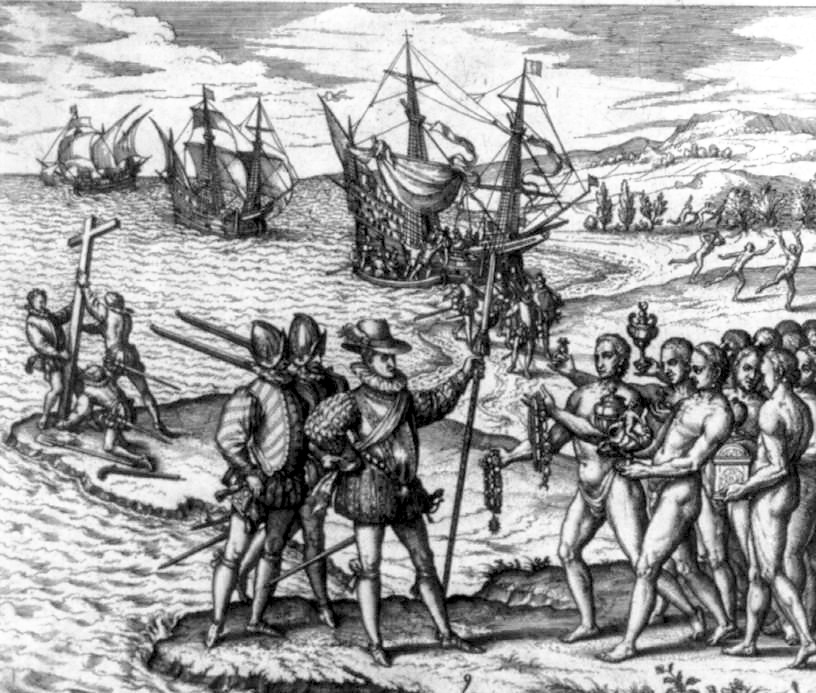
In 1504, Christopher Columbus, stranded on Jamaica during his fourth voyage, sent some crew members by canoe to Hispaniola for help. They ran into the island on the way, but it had no water. They called it Navaza (from "nava-" meaning plain, or field), and it was avoided by mariners for the next 350 years. From 1801 to 1867 the successive constitutions of Haiti claimed national sovereignty over adjacent islands, both named and unnamed, although Navassa was not specifically enumerated until 1874. Despite this implicit claim, Navassa Island was claimed for the United States on September 19, 1857, by Peter Duncan, an American sea captain, under the Guano Islands Act of 1856, for the rich guano deposits found on the island, and for not being within the lawful jurisdiction of any other government, nor occupied by another government's citizens. Haiti protested the annexation, but on July 7, 1858, U.S. President James Buchanan issued an Executive Order upholding the American claim, which also called for military action to enforce it. Navassa Island has since been maintained by the United States as an unincorporated territory (according to the Insular Cases). The United States Supreme Court on November 24, 1890, in Jones v. United States, 137 U.S. 202 (1890) Id. at 224 found that Navassa Island must be considered as appertaining to the United States, creating a legal history for the island under US law unlike many other islands originally claimed under the Guano Islands Act. As listed in its 1987 constitution, Haiti maintains its claim to the island. Guano phosphate is a superior organic fertilizer that became a mainstay of American agriculture in the mid-19th century. Duncan transferred his discoverer's rights to his employer, an American guano trader in Jamaica, who sold them to the newly formed Navassa Phosphate Company of Baltimore. After an interruption for the American Civil War, the company built larger mining facilities on Navassa with barrack housing for 140 black contract laborers from Maryland, houses for white supervisors, a blacksmith shop, warehouses, and a church. Mining began in 1865. The workers dug out the guano by dynamite and pick-axe and hauled it in rail cars to the landing point at Lulu Bay, where it was put into sacks and lowered onto boats for transfer to the Company barque, the S.S. Romance. The living quarters at Lulu Bay were called Lulu Town, as appears on old maps. Railway tracks eventually extended inland. Hauling guano by muscle-power in the fierce tropical heat, combined with general disgruntlement with conditions on the island, eventually provoked a rebellion in 1889, in which five supervisors died. A U.S. warship returned eighteen of the workers to Baltimore for three separate trials on murder charges. A black fraternal society, the Order of Galilean Fisherman, raised money to defend the miners in federal court, and the defense built its case on the contention that the men acted in self-defense or in the heat of passion, and that the United States did not have jurisdiction over the island. The cases, including Jones v. United States, 137 U.S. 202 (1890) went to the U.S. Supreme Court in October 1890, which ruled the Guano Act constitutional, and three of the miners were scheduled for execution in the spring of 1891. A grass-roots petition driven by black churches around the country, also signed by white jurors from the three trials, reached President Benjamin Harrison, who commuted the sentences to imprisonment and mentioned the case in a State of the Union Address. Guano mining resumed on Navassa at a much reduced level. The Spanish–American War of 1898 forced the Phosphate Company to evacuate the island and file for bankruptcy, and the new owners abandoned the island after 1901. Navassa became significant again with the opening of the Panama Canal in 1914. Shipping between the American eastern seaboard and the Canal goes through the Windward Passage between Cuba and Haiti. Navassa, a hazard to navigation, needed a lighthouse. The U.S. Lighthouse Service built Navassa Island Light, a 162-foot (49-meter) tower on the island in 1917, 395 feet (120 meters) above sea level. A keeper and two assistants were assigned to live there until the United States Lighthouse Service installed an automatic beacon in 1929. After absorbing the Lighthouse Service in 1939, the U.S. Coast Guard serviced the light twice each year. The U.S. Navy set up an observation post for the duration of World War II. The island has been uninhabited since then. Fishermen, mainly from Haiti, fish the waters around Navassa. A scientific expedition from Harvard University studied the land and marine life of the island in 1930. After World War II amateur radio operators occasionally visited to operate from the territory, which is accorded "entity" (country) status by the American Radio Relay League. The callsign prefix is KP1. From 1903 to 1917, Navassa was a dependency of the U.S. Guantanamo Bay Naval Base, and from 1917 to 1996 it was under United States Coast Guard administration. Since January 16, 1996, it has been administered by U.S. Department of the Interior. In 1996 the United States Coast Guard dismantled the light on Navassa. An inter-agency task force headed by the U.S. Department of State transferred oversight of the island to the U.S. Department of the Interior. By Secretary's Order No. 3205 of January 16, 1997, the Interior Department assumed control and placed the island under its Office of Insular Affairs. For statistical purposes, Navassa was grouped with the now-obsolete term United States Miscellaneous Caribbean Islands and is now grouped with other islands claimed by the U.S. under the Guano Islands Act as the United States Minor Outlying Islands. In 1997 an American salvager made a claim to Navassa to the Department of State based on the Guano Islands Act. On March 27, 1997, the Department of the Interior rejected the claim on the basis that the Guano Islands Act applies only to islands which, at the time of the claim, are not "appertaining to" the United States. The department's opinion said that Navassa is and remains a U.S. possession "appertaining to" the United States and is "unavailable to be claimed" under the Guano Islands Act. A 1998 scientific expedition led by the Center for Marine Conservation in Washington, D.C. described Navassa as "a unique preserve of Caribbean biodiversity." The island's land and offshore ecosystems have survived the 20th century virtually untouched. In 1999 the United States Fish and Wildlife Service assumed administrative responsibility for Navassa, which became a National Wildlife Refuge Overlay, also known as Navassa Island National Wildlife Refuge. The Office of Insular Affairs retains authority for the island's political affairs, and judicial authority is exercised directly by the nearest U.S. Circuit Court. Access to Navassa is hazardous and visitors need permission from the Fish and Wildlife Office in Boquerón, Puerto Rico to enter its territorial waters or land. Since this change of status, amateur radio operators have repeatedly been denied entry. In October 2014 permission was granted for a two-week DX-pedition in February 2015. The operation made 138,409 contacts.

Sans-Souci Palace

The Sans-Souci Palace was the royal residence of King Henri I of Haiti, Queen Marie-Louise and their two daughters. It was the most important of nine palaces built by the king, as well as fifteen châteaux, numerous forts, and sprawling summer homes on his twenty plantations. Construction of the palace started in 1810 and was completed in 1813. It is located in the town of Milot, Nord Department. Its name translated from French means "carefree." Before the construction of Sans-Souci, Milot was a French plantation that Christophe managed for a period during the Haitian Revolution. Many of Henri Christophes contemporaries noted his ruthlessness, and it is unknown how many laborers died during the palaces construction. Under his reign, the palace was the site of opulent feasts and dances. It had immense gardens, artificial springs, and a system of waterworks. Though Sans-Souci is now an empty ruin, at the time its splendor was noted by many foreign visitors. One American physician remarked that it had "the reputation of having been one of the most magnificent edifices of the West Indies." The impressiveness of Sans-Souci was part of Henri Christophes program to demonstrate to foreigners, particularly Europeans and Americans, the power and capability of the black race. The African pride in the construction of the kings palace was captured by the comment of his advisor, Pompée Valentin Vastey, who said that the palace and its nearby church, "erected by descendants of Africans, show that we have not lost the architectural taste and genius of our ancestors who covered Ethiopia, Egypt, Carthage, and old Spain with their superb monuments." However, Christophes reign drew heavily on European monarchical signs of prestige. He established a hereditary nobility, along with coats of arms and prescribed ceremonial dress. Close to the Palace is the renowned mountaintop fortress; the Citadelle Laferrière, built under decree by Henri Christophe to repel a feared French invasion that never occurred. It is reached by continuing on the trail behind the Palace. France, the former colonial power in Haiti, recognized Haitis independence in 1825 when Haiti agreed to pay a ruinous indemnity of 150 million francs in return for diplomatic and economic relations. Crippled by a stroke, King Henri I committed suicide on the grounds of the palace on October 8, 1820. According to Haitian legend, he shot himself with a silver bullet. He was subsequently buried in the Citadelle. His son and heir, Jacques-Victor Henry, Prince Royal of Haiti was bayoneted to death by revolutionaries at the Palace on October 18, 1820. Incidentally, the palace shares its name with another Haitian revolutionary leader, Colonel Jean-Baptiste Sans Souci. He was an African slave who may have taken his name from the quartier near the parish of Grande Rivière where he was a first led troops in guerrilla fighting against the French in 1791. When Henri Christophe and other military leaders split from the French, they asked Sans Souci to join their ranks, but he declined, and particularly viewed Christophe as a traitor. About ten years before the construction of his palace, the future Haitian king sent Colonel Sans Souci a conciliatory message inviting him to his headquarters at Grand Pré. When Sans Souci arrived at the plantation, Christophes guards bayoneted him and his small band of guards to death. Some scholars have also asked whether Christophe took part of his inspiration for the palace from the Prussian emperor Frederick the Greats palace in Potsdam, Sanssouci, a symbol of European Enlightenment achievement. A severe earthquake in 1842 destroyed a considerable part of the palace and devastated the nearby city of Cap-Haïtien; the palace was never rebuilt. The palace was acknowledged by many to be the Caribbean equivalent of the Palace of Versailles in France. UNESCO designated it—and the Citadelle—World Heritage Sites in 1982. Described as "one of the most remarkable attractions in the Western Hemisphere", the Palace of Sans-Souci is "seldom visited by foreigners" due to "decades of political instability and lawlessness" in Haiti. However, the area is relatively peaceful and easily accessible from the city of Cap-Haïtien.

Pic Macaya National Park

Pic Macaya National Park is one of two national parks of the Republic of Haiti. It is located in the countrys southern peninsula, within the Massif de la Hotte. Featuring the countrys last stand of virgin cloud forest, it encompasses more than 8,000 hectares. Elevations in the rugged park reach a maximum height of 2,347 meters above sea level at Pic Macaya, the second highest point in Haiti behind Pic la Selle. The park was founded in 1984, under the administration of Jean-Claude Duvalier. Originally composed of about 2,000 hectares, the park was expanded to more than 8,000 hectares in March 2013 as part of the Macaya Project. In December 2012, $12 million was pledged through 2017 in agreements with several international development agencies, including the Inter-American Development Bank and the Norwegian Agency for Development Cooperation. The initiative aims to increase protection of the parks natural resources by improving land management. This includes reforesting degraded areas, building infrastructure to reduce erosion from flooding, and enforcing the protection of the parks diverse plant and animal life. One of the biggest challenges to the park is the practice of "charcoal burning," in which large swathes of biomass are burned to produce charcoal, which can be sold at a high price by local inhabitants. The mountains of the Massif de la Hotte are mainly karstic and volcanic. The park features endangered plant and animal life, including some endemic to the island of Hispaniola. There are 220 species of birds present in the park, 141 species of orchids, and 367 flowering plants. Six species of frogs, believed to be extinct, have been seen the region in the past several years. Over 6,500 species of plants live at Pic Macaya.

This attraction is located in

This is a private property. Please enjoy respectfully and do not disturb the occupants.

Edit Categories
Add Tours

This attraction is not part of any tours

Add Collections

This attraction is not part of any collections


Some of the attractions we imported from Wikipedia are not perfect. Send us an email detailing what's wrong and we'll look into fixing it.

GuRoute is all about Gurus sharing their local knowledge. If you feel up to fixing this problem yourself, why not adopt it. You will become the owner and can fix whatever problems you see.

We've copied a link to this attraction into your clipboard so that ou can paste it into an email or text message...

More Info...
You can add your friends to the visit yourself, or, send them a link and let them add themselves...

The visit will appear on both your timelines and on your Shared Timeline.

Click below and we'll email you a link that you can send on to friends or post on your group's Facebook page.

If your friends aren't members of GuRoute yet, this is a great way to get them started.
Recent
Recently used Collections will appear here...
Recent
Recently used tours will appear here...

Where is this?

GuRoute likes to place attractions inside other attractions. So, maybe it's in a city, or maybe it's inside a particular park in that city. Maybe your attraction is a huge park that spans half the county, or multiple counties.

Determining where this attraction is gives it context - if it's in a park, you'll be able to see it alongside all the other attractions in that park. And that helps define the park.

GuRoute will automatically calculate a parent region for this attraction. You can change it if there is something more appropriate.

This attraction is currently located in .

Change

This attraction does not yet have any reviews

Please login to write a review...

Reviewed by
Record new Visit

Add this location to your timneline?

  • If there's an existing attraction open it and add it to your timeline...
  • If not, enter a title and we'll create a new attraction for your memories...
Create new Attraction

Create a new attraction at this location?

  • We rely on Gurus like you to share your local knowledge...
(Give a name for this location)


+
Add this to your timeline instead...

Imagine having a record of all the cool things you've done in your life!


Using our timeline you can keep track of everywhere you visit in your lifetime...

But, you'll need to sign in first...

Add contacts so that you can share your travels and record places that you visit together...

Family
Favorites
Family
Favorites

Profile TimeLine Our Visits Edit Accept Decline Invite

If you have any more friends that visited this place with you, feel free to add them to the visit. We'll write it to their timeline and once they confirm it, they too will have this memory for a lifetime.

If they're not already registered, you just need their name and email address and you can add them and we'll send them an invite on your behlaf.

Add a tour comment

Add some extra information for when this attraction is viewed as part of your tour...

Next Stop Instructions

Add some instructions for what to see/do on the way to the next stop...

Next Stop Instructions

Add some instructions for what to see/do on the way to the next stop...

If you're visiting an existing attraction, open it and add it to your timeline. If there is no attraction for the place you are visiting...

  • Click 'Add My Location' below
  • Or right-click on the map to mark a different location
  • Or long-press if you have a touch screen
You can even add locations while you're offline....
  • Load up the map when you're online and we'll keep track of your locaiton
  • You can add locations to your timeline
  • When you are online again we'll sync them with the cloud

We can't connect to the internet right now. The following attractions are saved locally and can be uploaded when you're online...

GuRoute would like to access your current location so that we can pin you on the map and show you nearby attractions

Add friends so that you can share your experiences with each other...

Add tour to What's Next?

Go...

Either for yourself or someone else...

  1. Do your trip research in GuRoute
    Add all the places that you think might be worthy of a visit into a trip-plan
  2. Add your trip-plan to your "What's Next" timeline
    (or a friend's "What's Next" timeline)
  3. When you're on vacation you'll have all your research at your fingertips
  4. Share your timline with your friends
    They can enjoy your vacation with you, seeing not only where you've been, but where you're going next...
  5. Add/remove attractions if things change

It also makes a great souvenir of your trip

Collections

Go...

Create a home page for a collection of attractions

  • Add an image and description to display on the homepage
  • Start adding content
    Add existing attractions to your collection or create new attractions of your own
  • Collections can be:
    • Public (Anyone can add attractions to your collection)
    • Shared (Only yourself and Gurus you nominate can add content)
    • Private (The collection will only be visible to yourself)

Uses

  • Local business or hotel
    Showcase local attractions that you endorse
  • Clubs
    Showcase attractions that members have created (eg. local historical society)
  • Special Interest
    If GuRoute does not have a category for your special interest you add your attractions to your own collection instead

Examples

Walking/Driving Tours

Go...

A guided tour where GuRoute will direct you from stop to stop and narrate a description of each attraction you arrive at

  • GuRoute uses your phone's GPS to guide you from stop to stop
  • GuRoute automatically detects when you arrive at the next tour-stop and narrates the description of the attraction (Chrome Only)
  • It then sends you on to the next stop

Tours are great to attract people to your town. Even places with no significant points of interest can be lots of fun when part of a tour


Cater tours to your Audience

  • Kid-friendly Tours
    • Focus on what will keep kids interested
    • Instead of parents having to drag their kids around they'll be struggling to keep up
    • Let the kids navigate and they'll get more fun out of finding that historical plaque than they ever would from reading it
  • Accessible tours
  • Short and long tours of the same location

What you need to do...

  1. Click 'Go...'
    Enter a title, description and location for the tour
  2. Add existing attractions OR create new ones and add them to the tour
  3. For existing attractions you can add more information specific to the theme of the tour
  4. You can also add instructions on what to do or see en-route to the next tour-stop
  5. Try out your tour and see how it works...

Mystery Tour

Go...

Create a Mystery Tour

Create a series of clues to show people around a city, neighborhood or whatever place you like...

  • GuRoute will show people clues to get them from attraction to attraction
  • When they reach each stop GuRoute will tell them about the place and give them the next clue
  • Take as long or as you like and explore each location at your leisure

Scavenger Hunt

Go...

Create a Scavenger Hunt

Create a series of questions that people have to answer. The answers can all be discovered by walking aroung the area, looking for clues.

  • How many beers are on tap at Michael Collin's Irish Bar?
  • What's the name of the oldest building on main streeet?
  • Show a picture of some public art and ask them what it is called
  • Clues can have numeric or multiple choice answers