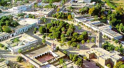
Sign In

My Timeline

GuRoute

Discover Your World

Share your Experiences

Record your Life


Top Attractions in Sinaloa

Mocorito

Mocorito is a small city and its surrounding municipality in the Mexican state of Sinaloa. It stands at 24°58′41″N 107°31′25″W. The city reported 5,426 inhabitants in the 2010 census. History In 1531 with the entry of the conqueror Nuño de Guzmán to northwest Mexico and the founding of the town of San Miguel de Navito, the geographical boundaries of the province of Culiacan started, subject to the governorship of New Galicia. In 1532, Sebastián de Évora reaches the valley Mocorito and called his name, the people and the river, leaving as encomendero dependent as mayor of the province of Culiacan, from that year was defined between the river towards Évora North and Elota River in the south. In 1594 the Mission Mocorito by the Jesuits Juan Bautista Hernando de Velasco and Santarán is founded.In 1732 when the Spanish arrived expansion beyond the Yaqui River, lays the territory divided into provinces. In this year rank first Sonora and Sinaloa to form a single governorship with head in the town of San Felipe and Santiago de Sinaloa, Sinaloa de Leyva today. In Sinaloa territory remained the internal division 3 provinces: Sinaloa, Culiacan, and Chametla, whose boundaries were May River north and south of Reeds. In 1749 the territory is divided into 5 provinces, and although apparently Mocorito came under the jurisdiction of the province of Culiacan in the ratio of "The Villages, Villas, places Indians and Royals Minas" stating their jurisdictions made in that time, appears within the jurisdiction of Culiacan, the peoples of Capirato, Comanito and Palos Blancos; and within the jurisdiction of Sinaloa, Mocorito mission and the people of San Benito. In 1813 the Constitution of Cadiz enters into force; Article 310 provides for the installation of municipalities in populations that had more than 1,000 inhabitants. In 1814, Fernando VII repeals the constitution but reinstalls it during 1820. From the moment the first municipalities in Sinaloa are installed. The creation of the internal state of the West in 1824 uniting the provinces of Sonora and Sinaloa, and the internal division of the state into five departments with their respective parties, does not alter the internal situation of Sinaloa territory in regard to Mocorito, since the Culiacán department is formed with the game of his name and Cosalá, comprising Mocorito region within the same, within the limits of the river its name to the river Elota. In 1830 the final separation of Sonora and Sinaloa decreed to form their independent states. The new state of Sinaloa was divided into eleven districts, being Mocorito one, comprising within its jurisdiction, the boundaries that mark on the north side of the coast, the town of Playa Colorada, and towards the mountains, the town of Corral Quemado, adjoining district Badiraguato; by the same mountain, south bordering on the district and the town of Culiacan Ocualtita; towards Jesús María almost reaching the coast, the town of Aguapepe and Awnings, opposite the island of Tachichilte. Mocorito was erected municipality by decree published on April 8, 1915. In 1916 Mocorito suffer a reduction in their geographical extension to become political in Municipality Directorate of Angostura. In 1962 suffers a further reduction to settle the town of Salvador Alvarado. Flora and Fauna In Mocorito can perfectly identify three climatic regions found the Sinaloa: tropical savannah west; mountainous in the east and a transition zone in the central area, so three levels of vegetation are distinguished: The conifers, oaks, oaks and pines in the high mountains; amapas, ebony, cedars and junipers in its foothills, and herbs and shrubs in the coastal area where mangroves thrive, guamuchileros, mesquite and wild figs.Most of the farmland are temporary, with crops such as rice, soybean, safflower, corn, cottonseed, sesame, beans, sorghum and cotton in bales, sugarcane, corn; fruits such as cantaloupe, watermelon, avocado, mango, orange and papaya. In Mocorito breeds, some important animals are cattle, pigs, goats and sheep. Among the wild animals we find the deer, hare, rabbit, armadillo, iguana and others; and wild animals such as wild cat, tiger and lion living in the most abrupt of the saw. Origin of the name Don Hector Rodelo. Olea said that Mocorito is a variant Cahita word "Macori-to", composed of Macuri, short for "macorihui" a voice alteration "macoyahuy" objective applied to a fraction of the Mayo Indians or people who speak a dialect the Cahita language; Further, the position "to" denoting location, place; the place name means "place of nations who speak a dialect of Cahita tongue, or inhabited by Mayan Indians or macoritos". Other historians as the Lic. Eustaquio Buelnal prefers Mocorito translate as "place of the dead". The Shield Meaning Finding Mayor Eng. Luis Verduzco Leal, shield Township Mocorito was developed in 1964 by Mr. Miguel Angel Velazquez Tracy, shaping oval, tronchado band and quartered, with bordura imitating stone in honor of Indian origin, in ignorance Metal and footprints oriented northwest and southeast in greater numbers and from southeast to northwest lesser number, meaning nahoa pilgrimage to give Sinaloa population, and Mocorito in particular.In the first quarter sable coat background is seen, meaning the darkness of prehistory. The second quarter, enamelled purple to signify the dawn of history Mocorito. Substance and orange, a building of defense, meaning the city of San Miguel de Culiacán; south another figure in blue formed by two strong arms that mean the Humaya river and Tamazula. Leaving these figures orange band passing over a thinner band blue which means the road from Culiacan and passing over the river to the Petatlán Mocorito, also representing the Villa de San Felipe y Santiago. In the third quarter, silver background, a chapel of indigenous stroke, dated 1594, meaning the foundations mission Mocorito. In the fourth quarter, gold background symbolizing the zenith of colonial history, the present church, and on it a drop of orange comes from a hill symbolizing gold mining. The flamboyant robe off bordura means patriotic movements, open book with the dates 1857-1917 constitutions, and bronze eagle with outspread wings means the country, holding a banner with the words "State of Sinaloa". Carnival The carnival has been held Mocorito years ago. The first day people gather expecting the identity of temper that evening burn is known. The second day is the crowning of the Queen of the Floral Games. On the third day takes place the coronation of the Queen of Carnival. On Sunday is the first tour of floats and bands. Monday is the coronation of the Kings and Children ride floats and to close with a flourish, on Tuesday performed the traditional walk, to the best allegorical cars and bands are rewarded and culminates with a large popular dance. Music The music could not miss as it is one of the deepest traditions. José Rubio Quinonez heir of the Sinaloa music, promoter of the popular bands of Sinaloa. The band "Los Hermanos Rubio Mocorito" has toured the country from Tijuana to Mexico City, playing the merry notes of the drum: sones "The Lost Child", "El Toro Viejo", "Brisas de Mocorito", "The Sinaloa "," El Palo Verde "and many more. Characters and Artist of Mocorito Mocorito was called at a time "The Athens Sinaloa" as it has been distinguished by its innate vocation to the fine arts. It was the seat of a cultural range that is proud of Sinaloa. Several are in Mocorito found inspiration for their works whether literary, artistic, historical or transformative. The great muralist David Alfaro Siqueiros recalled that in this place joined the forces of revolution. When he was released he intended to return to the place as a symbolism reiterating its struggle for a better Mexico. JOSE RAMON VELAZQUEZ, writer of facts and anecdotes. Their stories come from the voices of people with their main theme is Mocorito. HECTOR LOPEZ GAMEZ, painter Mocoritense, majored in Law and Social Sciences obligation, then studied fine arts for fun in a US school. He leans in the human figure, landscapes and surreal themes.ERNESTO RIOS, painter and muralist Mocoritense. In the beginning he focused portrait of those who managed to make more than three thousand in four years later, mature, he was attracted by the murals have given popularity with shows several Mexican states projecting that done in Revolution Park Culiacan and the library of the Autonomous University of Sinaloa in Guamúchil. DR. ENRIQUE PEÑA GUTIERREZ, physician, poet and writer. He was part of a scientific committee that made the study of leprosy and tuberculosis in Sinaloa to the Mexican Academy of Medicine. Then he took up farming producing FERTIMOC, fertilizer helps to have increased production in crops. He edited the magazine "gaps" and wrote the book "Were Five Horse" among others. DR. JOSE DOMINGUEZ LAW, medical, humanitarian, philanthropist and social activist. Concerned about the village, founded the Ateneo Professor Constancio Rodriguez gave luster to Mocorito in the cultural both regionally and nationally, for its management connection to electricity CFE was achieved. The water system was introduced, the recognition of high school, health center, among others. He was a fighter always upright for unprotected world.

Costa Rica

Costa Rica is the name of a small town located about 30 minutes south of Culiacán, Sinaloa, Mexico. In its beginnings Costa Rica was a small peasant town created due to the existence of the sugar cane processing plant that was there. In the 1960s, there were just about 15,000 people in the town but it was thriving with commerce. Its people were known to be very polite. There were 2 movie theaters and plenty of restaurants. The more popular places were the Farmacia Del Capi, El Restaurante Lety, La Neveria De Juvencio, El Mercado Nuevo and La Ferreteria Gutierrez, among others. The sugar cane industry was very prosperous. Then came the closing of the plant due to mismanagement and thousands became unemployed. Now most employment is offered by the service sector, but people continue to struggle to make ends meet. Like other cities in Mexico, the city of Costa Rica, Sinaloas condition is a result of corruption and narcotraffic. While most of the people try to make an honest living, there is a part of the population that live out of the narcotraffic business. Costa Rica, Sinaloa is a city plagued by corruption, a city where stolen cars are driven freely and the authorities do not care about it as long as they receive their cut. Costa Rica, Sinaloa is a city full of brand new cars and dirt roads. Where many businesses flourish without paying taxes, which contribute to the lack of public services available in the city. But as of late more of the citys tax money is being used for the prosperity of the people of Costa Rica, which includes its first street light. Grupero music is very popular in this town, including corridos.

Huites Dam

Huites Dam, officially known as Luis Donaldo Colosio Dam, is located on the Rio Fuerte in northwestern Sinaloa, Mexico 130 kilometres northeast of Los Mochis. The 162-metre (531 ft)-high, hybrid concrete arch-gravity dam impounds a reservoir called Lago Huites or Presa Luís Donaldo Colosio and is owned by the Comisión Federal de Electricidad. The construction of a dam on the upper Rio Fuerte was considered since the 1940s but the first detailed studies were not made until 1974–1977. Construction started in 1992 with the excavation of a diversion channel around the dam site and the implementation of a pair of cofferdams to protect the site from floods. About 485,000 cubic metres (634,000 cu yd) of material was excavated from the site before construction on the actual dam could begin. Placement of the 2,980,000 cubic metres (3,900,000 cu yd) of concrete in the dam, hydroelectric power plant and spillway structures was completed in 29 months, with the workforce peaking at 2,671 in May 1993. Construction was completed in 1995 at a cost of roughly US$ 212 million. The dam's two generators were commissioned on 15 September 1996. The impounded water behind the dam forms a reservoir with a capacity of 4.568 cubic kilometres (3,703,000 acre·ft), of which 2.908 cubic kilometres (2,358,000 acre·ft) is active capacity and 2.408 cubic kilometres (1,952,000 acre·ft) is reserved for irrigation and power production. About 1.102 cubic kilometres (893,000 acre·ft) are given exclusively for flood control. Floodwaters are released through a spillway on the south side of the dam, controlled by four 15.5 m × 21.0 m (50.9 ft × 68.9 ft) radial gates. Water stored in the reservoir is used to provide irrigation to 89,700 hectares (222,000 acres) of land in the Fuerte River valley. The dam's power plant has two Francis turbines with a combined generating capacity of 422 megawatts (MW) and produces an average of 875 million KWh annually. At full capacity, the plant utilizes a water flow of 235 m3/s (8,300 cu ft/s).

This attraction is located in

This is a private property. Please enjoy respectfully and do not disturb the occupants.

Edit Categories
Add Tours

This attraction is not part of any tours

Add Collections

This attraction is not part of any collections


Some of the attractions we imported from Wikipedia are not perfect. Send us an email detailing what's wrong and we'll look into fixing it.

GuRoute is all about Gurus sharing their local knowledge. If you feel up to fixing this problem yourself, why not adopt it. You will become the owner and can fix whatever problems you see.

We've copied a link to this attraction into your clipboard so that ou can paste it into an email or text message...

More Info...
You can add your friends to the visit yourself, or, send them a link and let them add themselves...

The visit will appear on both your timelines and on your Shared Timeline.

Click below and we'll email you a link that you can send on to friends or post on your group's Facebook page.

If your friends aren't members of GuRoute yet, this is a great way to get them started.
Recent
Recently used Collections will appear here...
Recent
Recently used tours will appear here...

Where is this?

GuRoute likes to place attractions inside other attractions. So, maybe it's in a city, or maybe it's inside a particular park in that city. Maybe your attraction is a huge park that spans half the county, or multiple counties.

Determining where this attraction is gives it context - if it's in a park, you'll be able to see it alongside all the other attractions in that park. And that helps define the park.

GuRoute will automatically calculate a parent region for this attraction. You can change it if there is something more appropriate.

This attraction is currently located in .

Change

This attraction does not yet have any reviews

Please login to write a review...

Reviewed by
Record new Visit

Add this location to your timneline?

  • If there's an existing attraction open it and add it to your timeline...
  • If not, enter a title and we'll create a new attraction for your memories...
Create new Attraction

Create a new attraction at this location?

  • We rely on Gurus like you to share your local knowledge...
(Give a name for this location)


+
Add this to your timeline instead...

Imagine having a record of all the cool things you've done in your life!


Using our timeline you can keep track of everywhere you visit in your lifetime...

But, you'll need to sign in first...

Add contacts so that you can share your travels and record places that you visit together...

Family
Favorites
Family
Favorites

Profile TimeLine Our Visits Edit Accept Decline Invite

If you have any more friends that visited this place with you, feel free to add them to the visit. We'll write it to their timeline and once they confirm it, they too will have this memory for a lifetime.

If they're not already registered, you just need their name and email address and you can add them and we'll send them an invite on your behlaf.

Add a tour comment

Add some extra information for when this attraction is viewed as part of your tour...

Next Stop Instructions

Add some instructions for what to see/do on the way to the next stop...

Next Stop Instructions

Add some instructions for what to see/do on the way to the next stop...

If you're visiting an existing attraction, open it and add it to your timeline. If there is no attraction for the place you are visiting...

  • Click 'Add My Location' below
  • Or right-click on the map to mark a different location
  • Or long-press if you have a touch screen
You can even add locations while you're offline....
  • Load up the map when you're online and we'll keep track of your locaiton
  • You can add locations to your timeline
  • When you are online again we'll sync them with the cloud

We can't connect to the internet right now. The following attractions are saved locally and can be uploaded when you're online...

GuRoute would like to access your current location so that we can pin you on the map and show you nearby attractions

Add friends so that you can share your experiences with each other...

Add tour to What's Next?

Go...

Either for yourself or someone else...

  1. Do your trip research in GuRoute
    Add all the places that you think might be worthy of a visit into a trip-plan
  2. Add your trip-plan to your "What's Next" timeline
    (or a friend's "What's Next" timeline)
  3. When you're on vacation you'll have all your research at your fingertips
  4. Share your timline with your friends
    They can enjoy your vacation with you, seeing not only where you've been, but where you're going next...
  5. Add/remove attractions if things change

It also makes a great souvenir of your trip

Collections

Go...

Create a home page for a collection of attractions

  • Add an image and description to display on the homepage
  • Start adding content
    Add existing attractions to your collection or create new attractions of your own
  • Collections can be:
    • Public (Anyone can add attractions to your collection)
    • Shared (Only yourself and Gurus you nominate can add content)
    • Private (The collection will only be visible to yourself)

Uses

  • Local business or hotel
    Showcase local attractions that you endorse
  • Clubs
    Showcase attractions that members have created (eg. local historical society)
  • Special Interest
    If GuRoute does not have a category for your special interest you add your attractions to your own collection instead

Examples

Walking/Driving Tours

Go...

A guided tour where GuRoute will direct you from stop to stop and narrate a description of each attraction you arrive at

  • GuRoute uses your phone's GPS to guide you from stop to stop
  • GuRoute automatically detects when you arrive at the next tour-stop and narrates the description of the attraction (Chrome Only)
  • It then sends you on to the next stop

Tours are great to attract people to your town. Even places with no significant points of interest can be lots of fun when part of a tour


Cater tours to your Audience

  • Kid-friendly Tours
    • Focus on what will keep kids interested
    • Instead of parents having to drag their kids around they'll be struggling to keep up
    • Let the kids navigate and they'll get more fun out of finding that historical plaque than they ever would from reading it
  • Accessible tours
  • Short and long tours of the same location

What you need to do...

  1. Click 'Go...'
    Enter a title, description and location for the tour
  2. Add existing attractions OR create new ones and add them to the tour
  3. For existing attractions you can add more information specific to the theme of the tour
  4. You can also add instructions on what to do or see en-route to the next tour-stop
  5. Try out your tour and see how it works...

Mystery Tour

Go...

Create a Mystery Tour

Create a series of clues to show people around a city, neighborhood or whatever place you like...

  • GuRoute will show people clues to get them from attraction to attraction
  • When they reach each stop GuRoute will tell them about the place and give them the next clue
  • Take as long or as you like and explore each location at your leisure

Scavenger Hunt

Go...

Create a Scavenger Hunt

Create a series of questions that people have to answer. The answers can all be discovered by walking aroung the area, looking for clues.

  • How many beers are on tap at Michael Collin's Irish Bar?
  • What's the name of the oldest building on main streeet?
  • Show a picture of some public art and ask them what it is called
  • Clues can have numeric or multiple choice answers