Sign In

My Timeline

GuRoute

Discover Your World

Share your Experiences

Record your Life


Top Attractions in Nusa Tenggara Barat

Gili Islands

The Gili Islands are an archipelago of three small islands — Gili Trawangan, Gili Meno and Gili Air — just off the northwest coast of Lombok, Indonesia. The islands are a popular destination for tourists. Each island has several small resorts, usually consisting of a collection of huts for tourists, a small pool and restaurant. Most local inhabitants live on Trawangan in a township stretching along its east side just inland (which is also where most recent development is taking place). Automobiles and motorised traffic are prohibited on the islands by local ordinance, so the preferred method of transportation is by foot and bicycle or the horse-drawn carriage called a cidomo. Scuba diving and freediving in and around the Gilis is also popular due to the abundance of marine life and attractive coral formations. Most famous diving spots are Shark point, Manta point and Simon's reef. The name "Gili Islands" is a misnomer, because Gili simply means "small island" in Sasak. As a result, most of the islands around the coast of Lombok have Gili in their names, although confusion is averted by referring (in English) to the other Gilis around the Lombok coast by their proper names only. The Indonesian word for water is Air ([aˈjɛr]; AH-yer) and Gili Air was named for being the only island of the three to have subterranean fresh water. This is acknowledged as a finite resource with some resorts and restaurants shipping in the water from the mainland. The Islands are located in the Lombok Strait, to the immediate northwest of Lombok. They extend outward from a tiny peninsula called Sire near to the village of Tanjung on Lombok. Bali lies about 35 km to the west of Gili Trawangan, the islands' most westerly member. Both Bali and Lombok are easily visible from the Gilis in clear weather. Mount Rinjani, Indonesia's second highest volcano, is close by on neighbouring Lombok, and dominates the views towards the east. Due to their close proximity to the Equator, the Islands have a warm, Tropical climate with a dry and wet season. With Mount Rinjani to the immediate east on Lombok, and Mount Agung to the west on Bali, The Gilis are somewhat sheltered and actually enjoy a slightly drier Microclimate when compared to the surrounding archipelago. Dry Season usually lasts from May until October, with Monsoon season starting in November and continuing through to April. Temperatures range between 22 °C to 34 °C, with an average annual temperature of around 28 °C.

Gili Trawangan

Gili Trawangan is the largest of Lombok's Gili Islands and the only one to rise significantly (30 m) above sea level. Measuring 3 km long and 2 km wide, it has a population of around 1500 (see demography). The name Trawangan originates from the Indonesian word Terowongan (Tunnel) due to the presence of a cave tunnel built there during Japanese occupation in World War 2. Of the Gilis, Trawangan is the most developed and geared towards tourism. The main concentration of settlement, recreation, accommodation and diving business is situated on the eastern side of the island. A local pub, Tîr na Nôg claims that Trawangan is the smallest island in the world with an Irish pub. It was previously administered under Lombok Barat Regency along with Senggigi until 2010 when the Gili islands came under the jurisdiction of the new North Lombok Regency (Kabupaten Lombok Utara). On Gili Trawangan (as well as the other two Gilis), there are no motorised vehicles. The main means of transportation are bicycles (rented by locals to tourists) and cidomo (a small horse-drawn carriage). For travelling to and from each of the Gilis, locals usually use motorised boats and speedboats. Some of the first inhabitants of Gili Trawangan were fishermen and farmers from Sulawesi. Previous to human settlement Gili Trawangan was covered in forest and deer lived on the island. (Source: Inhabitants of Gili Trawangan — no printed source available). The economy of Gili Trawangan centres on tourism, as the island is too small to support any broad scale agriculture, and too remote to allow economically viable industry or commerce. There is a mosque on the island. Gili Trawangan has had a reputation since the 1980s as a location where drugs are freely available. Psilocybin mushrooms are openly advertised on the island, and a range of harder drugs have been known to be in circulation. Though police presence is low, Indonesian drug laws are extremely harsh and thus strictly speaking drug possession and use is prohibited and carries potentially grave risk (up to and including the death penalty). In recent years, locally made spirits have caused casualties and even some fatalities among tourists and locals, due to methanol poisoning. Methanol is sometimes used by locals as a cheap way of topping up their stock. The most recent case of this was on New Year's Eve 2012, where a young man was served a cocktail at Rudy's bar that had been infused with methanol. Following misdiagnoses in Indonesia and repatriation, he died 5 days later.

Mount Tambora

Mount Tambora is an active stratovolcano which is a peninsula of the island of Sumbawa, Indonesia. Sumbawa is flanked both to the north and south by oceanic crust, and Tambora was formed by the active subduction zone beneath it. This raised Mount Tambora as high as 4,300 m, making it, in the 18th century, one of the tallest peaks in the Indonesian archipelago. After a large magma chamber inside the mountain filled over the course of several decades, volcanic activity reached a historic climax in the eruption of 10 April 1815. This eruption was about a volcanic explosivity index of 7, the only unambiguously confirmed VEI-7 eruption since the Lake Taupo eruption in about AD 180. With an estimated ejecta volume of 160 km3, Tamboras 1815 outburst is the largest volcanic eruption in recorded history. The explosion was heard on Sumatra, more than 2,000 km away. Heavy volcanic ash falls were observed as far away as Borneo, Sulawesi, Java, and the Maluku Islands. Most of the deaths from the eruption were from starvation and disease, as the eruptive fallout ruined agricultural productivity in the local region. The death toll was at least 71,000 people, of whom 11,000–12,000 were killed directly by the eruption; the oft-cited figure of 92,000 people killed is believed to be an overestimate. The eruption caused global climate anomalies that included the phenomenon known as "volcanic winter": 1816 became known as the "Year Without a Summer" because of the effect on North American and European weather. Crops failed and livestock died in much of the Northern Hemisphere, resulting in the worst famine of the 19th century. During an excavation in 2004, a team of archaeologists discovered cultural remains buried by the 1815 eruption. They were kept intact beneath the 3m-deep pyroclastic deposits. At the site, dubbed the "Pompeii of the East", the artifacts were preserved in the positions they had occupied in 1815.

Sumbawa

Sumbawa is an Indonesian island, in the middle of the Lesser Sunda Islands chain, with Lombok to the west, Flores to the east, and Sumba further to the southeast. It is part of the province of West Nusa Tenggara, but there are presently steps being taken by the Indonesian government to turn the island into a separate province. Traditionally the island is known as the source of sappanwood used to make red dye, as well as honey and sandalwood. Its savanna-like climate and vast grassland is used to breed horses and cattle and to hunt deer. Sumbawa has an area (including minor offshore islands) of 15,448 square kilometres or 5,965 square miles (three times the size of Lombok) with a current population (January 2014) of around 1.39 million. It marks the boundary between the islands to the west, which were influenced by religion and culture spreading from India, and the region to the east that was less influenced. In particular this applies to both Hinduism and Islam. == History == The 14th-century Nagarakretagama mentioned several principalities identified to be on Sumbawa; Dompu, Bima, Sape and Sang Hyang Api volcanic island just offcoast of northeast Sumbawa. Four principalities in western Sumbawa were dependencies of the Majapahit Empire of eastern Java. Because of Sumbawa's natural resources, it was regularly invaded by outside forces – from Javanese, Balinese, Makassarese, Dutch and Japanese. The Dutch first arrived in 1605, but did not effectively rule Sumbawa until the early 20th century. The Balinese kingdom of Gelgel ruled western Sumbawa for a short period as well. The eastern parts of the island were also home to the Sultanate of Bima, an Islamic polity that had links to Bugis and Makasarese people of South Sulawesi, as well as other Malay-Islamic polities in the archipelago. Historical evidence indicates that people on Sumbawa island were known in the East Indies for their honey, horses, sappan wood for producing red dye, and sandalwood used for incense and medications. The area was thought to be highly productive agriculturally. In the 18th century the Dutch introduced coffee plantation on the western slopes of Mount Tambora, thus creating the Tambora coffee variant. == Administration == Sumbawa is administratively divided into four regencies (kabupaten) and one kota (city). They are: == Demographics == Islam was introduced via the Makassarese language of Sulawesi island. Sumbawa has historically had two major linguistic groups who spoke languages that were unintelligible to each other. One group centered in the western side of the island speaks Basa Semawa (Indonesian: Bahasa Sumbawa) which is similar to the Sasak language from Lombok; the second group in the east speaks Nggahi Mbojo (Bahasa Bima). They were once separated by the Tambora culture, which spoke a language related to neither. After the demise of Tambora, the kingdoms located in Sumbawa Besar and Bima were the two focal points of Sumbawa. This division of the island into two parts remains today; Sumbawa Besar and Bima are the two largest towns on the island, and are the centers of distinct cultural groups that share the island. The population of the island (including minor outliers) was 1.33 million at the latest decennial census in 2010, comprising 29.58% of the population of the entire province's with 4.5 million people. Due to lack of work opportunities on the island and its frequent droughts (unlike wet Bali), many people on the island seek work in the Middle East as laborers or domestic servants; some 500,000 workers, or over 10% of the population of West Nusa Tenggara, have left the country to work overseas. == Geography == The island is bound by bodies of water; to the west is Alas Strait, south is the Indian Ocean, Saleh Bay creates a major north-central indentation in the island, and the Flores Sea runs the length of the northern coastline. The Sape Strait lies to the east of the island and separates Sumbawa from Flores and the Komodo Islands, there are a number bays and gulfs, most notably Bima Bay, Cempi Bay, and Waworada Bay Sumbawa's most distinguishing feature is Saleh Bay and the Tambora Peninsula with Mount Tambora. Highlands rise in four spots on the island, as well as on Sangeang Island, the large western lobe of Sumbawa is dominated by a large central highland, there is Mt. Tambora, Dompu and Bima each have more minor highlands. There are a number of large surrounding islands, most notably are Moyo Island, volcanically active Sangeang Island, and the tourist Komodo Islands (administered under Flores) to the east. === List of offshore islands === There are a number of smaller offshore islands which fall within the regencies based on Sumbawa Island:
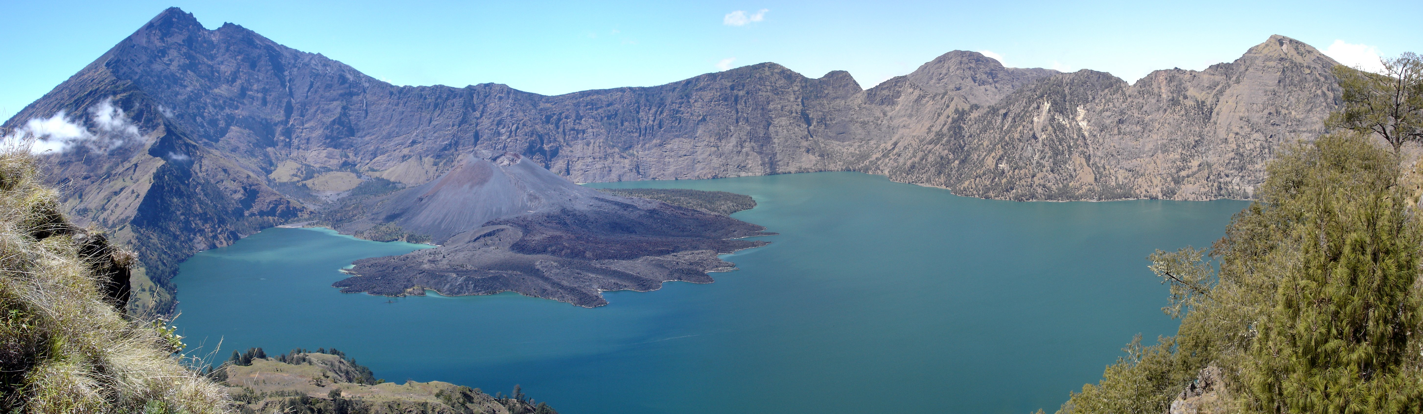
 == Volcanoes == Sumbawa lies within the Pacific Ring of Fire. It is a volcanic island, including Mount Tambora (8°14’41”S, 117°59’35”E) which exploded in April 1815, the most destructive volcanic eruption in modern history (roughly four times larger than the 1883 eruption of Krakatoa, between Java and Sumatra, in terms of volume of magma ejected). The eruption killed as many as 72,000. It also apparently destroyed a small culture of Southeast Asian affinity, known to archaeologists as the Tambora culture. It launched 100 cubic kilometres (24 cu mi) of ash into the upper atmosphere, which caused 1816 to be the "year without a summer". [2] == Economy == Many of the island residents are at risk of starvation when crops fail due to lack of rainfall. The majority of the population works in agriculture. Tourism is very nascent, with a few surf spots renowned for being world class, Jelenga and Supersuck Beaches near the mine, as well as Hu'u and Lakey Beach in the Gulf of Cempi. Due to the mine, Sumbawa Barat Regency (statistically), along with other remote mining towns, and Jakarta, have the highest GDP per capita rates in Indonesia, Sumbawa Barat's is 156.25 million rupiah ($17,170 USD) as of 2010, yet it is an area that sees entrenched, repeated starvation deaths and severe malnutrition in children. === Newmont Mine === The Southwestern extreme portion of Sumbawa is monopolized by American firm Newmont Mining Corporation; a large gold and copper mine, Newmont's Batu Hijau mine in Sumbawa began commercial operations in 2000, a decade after the copper and gold were discovered. Newmont holds a 45% stake in the operation through its shareholding in PT Newmont Nusa Tenggara. A local unit of Japan's Sumitomo Corporation has a 35% share. Newmont and its partners have invested about $1.9 billion in the mine. The reserves are expected to last until 2034, making Batu Hijau one of the largest copper mines in the world. Newmont has been accused of being involved in scandals of mercury and arsenic poisoning in Sulawesi Island, as well as having been embroiled in pollution cases on four continents. Protests on Sumbawa where police fired on protesters of a different gold project did not involve Newmont operations. == Transport == There is a road network in Sumbawa, but it is poorly maintained and has long portions of rough gravel. Frequent ferry service to Sumbawa (Poto Tano) from Lombok (Labuhan Lombok) exists, however ferry service to Flores from Sape is infrequent. Bima is the largest city on Sumbawa and has ferry and bus service directly to Java and Bali, though service breakdowns are common.

Mataram

Mataram is the capital of the Indonesian province of West Nusa Tenggara. The city is surrounded on all the landward sides by (but is not administratively contained within) West Lombok Regency (Kabupaten Lombok Barat) and lies on the western side of the island of Lombok, Indonesia. It is also the largest city of the province, and had a population of 402,296 at the 2010 Census; the latest official estimate (as at January 2014) is 420,941. In addition to serving as the provincial capital, Mataram has also become the center of government, education, commerce, industry and services. Three towns constitute the Mataram area; from west to east, these are Ampenan, Mataram, and Cakranegara. They are distinct towns, but run together. Broadly, Ampenan is an aging seaport city, Mataram is the governmental and office center for the province, and Cakranegara is the major commercial center on the island. The city is administratively divided into six districts (kecamatan), namely Ampenan, Cakranegara, Mataram, Pejanggik, Selaparang, and Sekarbela. The Mataram area contains 50 Kampungs (villages/neighbourhoods) and 297 (RT) kampung sub-sections. The city is served by the Lombok International Airport (Bandara Internasional Lombok) (IATA: LOP, ICAO: WADL) near Praya in Central Lombok, by the Lembar Harbour seaport in the southwest and Labuhan Lombok ferry port on the east coast which provides connection to Poto Tano on Sumbawa. Mataram is located near west coast of Lombok, so it is very close to the island's tourism centre of Senggigi beach, which is a short distance northward from Ampenan. Mataram was previously a part of West Lombok Regency before the division of the regency in 2000, when the capital of West Lombok was moved to Gerung. Mataram was also the seat of power for the king of Mataram (Seraja), which was sometimes controlled through neighboring Singaraja, Bali.

This attraction is located in

This is a private property. Please enjoy respectfully and do not disturb the occupants.

Edit Categories
Add Tours

This attraction is not part of any tours

Add Collections

This attraction is not part of any collections


Some of the attractions we imported from Wikipedia are not perfect. Send us an email detailing what's wrong and we'll look into fixing it.

GuRoute is all about Gurus sharing their local knowledge. If you feel up to fixing this problem yourself, why not adopt it. You will become the owner and can fix whatever problems you see.

We've copied a link to this attraction into your clipboard so that ou can paste it into an email or text message...

More Info...
You can add your friends to the visit yourself, or, send them a link and let them add themselves...

The visit will appear on both your timelines and on your Shared Timeline.

Click below and we'll email you a link that you can send on to friends or post on your group's Facebook page.

If your friends aren't members of GuRoute yet, this is a great way to get them started.
Recent
Recently used Collections will appear here...
Recent
Recently used tours will appear here...

Where is this?

GuRoute likes to place attractions inside other attractions. So, maybe it's in a city, or maybe it's inside a particular park in that city. Maybe your attraction is a huge park that spans half the county, or multiple counties.

Determining where this attraction is gives it context - if it's in a park, you'll be able to see it alongside all the other attractions in that park. And that helps define the park.

GuRoute will automatically calculate a parent region for this attraction. You can change it if there is something more appropriate.

This attraction is currently located in .

Change

This attraction does not yet have any reviews

Please login to write a review...

Reviewed by
Record new Visit

Add this location to your timneline?

  • If there's an existing attraction open it and add it to your timeline...
  • If not, enter a title and we'll create a new attraction for your memories...
Create new Attraction

Create a new attraction at this location?

  • We rely on Gurus like you to share your local knowledge...
(Give a name for this location)


+
Add this to your timeline instead...

Imagine having a record of all the cool things you've done in your life!


Using our timeline you can keep track of everywhere you visit in your lifetime...

But, you'll need to sign in first...

Add contacts so that you can share your travels and record places that you visit together...

Family
Favorites
Family
Favorites

Profile TimeLine Our Visits Edit Accept Decline Invite

If you have any more friends that visited this place with you, feel free to add them to the visit. We'll write it to their timeline and once they confirm it, they too will have this memory for a lifetime.

If they're not already registered, you just need their name and email address and you can add them and we'll send them an invite on your behlaf.

Add a tour comment

Add some extra information for when this attraction is viewed as part of your tour...

Next Stop Instructions

Add some instructions for what to see/do on the way to the next stop...

Next Stop Instructions

Add some instructions for what to see/do on the way to the next stop...

If you're visiting an existing attraction, open it and add it to your timeline. If there is no attraction for the place you are visiting...

  • Click 'Add My Location' below
  • Or right-click on the map to mark a different location
  • Or long-press if you have a touch screen
You can even add locations while you're offline....
  • Load up the map when you're online and we'll keep track of your locaiton
  • You can add locations to your timeline
  • When you are online again we'll sync them with the cloud

We can't connect to the internet right now. The following attractions are saved locally and can be uploaded when you're online...

GuRoute would like to access your current location so that we can pin you on the map and show you nearby attractions

Add friends so that you can share your experiences with each other...

Add tour to What's Next?

Go...

Either for yourself or someone else...

  1. Do your trip research in GuRoute
    Add all the places that you think might be worthy of a visit into a trip-plan
  2. Add your trip-plan to your "What's Next" timeline
    (or a friend's "What's Next" timeline)
  3. When you're on vacation you'll have all your research at your fingertips
  4. Share your timline with your friends
    They can enjoy your vacation with you, seeing not only where you've been, but where you're going next...
  5. Add/remove attractions if things change

It also makes a great souvenir of your trip

Collections

Go...

Create a home page for a collection of attractions

  • Add an image and description to display on the homepage
  • Start adding content
    Add existing attractions to your collection or create new attractions of your own
  • Collections can be:
    • Public (Anyone can add attractions to your collection)
    • Shared (Only yourself and Gurus you nominate can add content)
    • Private (The collection will only be visible to yourself)

Uses

  • Local business or hotel
    Showcase local attractions that you endorse
  • Clubs
    Showcase attractions that members have created (eg. local historical society)
  • Special Interest
    If GuRoute does not have a category for your special interest you add your attractions to your own collection instead

Examples

Walking/Driving Tours

Go...

A guided tour where GuRoute will direct you from stop to stop and narrate a description of each attraction you arrive at

  • GuRoute uses your phone's GPS to guide you from stop to stop
  • GuRoute automatically detects when you arrive at the next tour-stop and narrates the description of the attraction (Chrome Only)
  • It then sends you on to the next stop

Tours are great to attract people to your town. Even places with no significant points of interest can be lots of fun when part of a tour


Cater tours to your Audience

  • Kid-friendly Tours
    • Focus on what will keep kids interested
    • Instead of parents having to drag their kids around they'll be struggling to keep up
    • Let the kids navigate and they'll get more fun out of finding that historical plaque than they ever would from reading it
  • Accessible tours
  • Short and long tours of the same location

What you need to do...

  1. Click 'Go...'
    Enter a title, description and location for the tour
  2. Add existing attractions OR create new ones and add them to the tour
  3. For existing attractions you can add more information specific to the theme of the tour
  4. You can also add instructions on what to do or see en-route to the next tour-stop
  5. Try out your tour and see how it works...

Mystery Tour

Go...

Create a Mystery Tour

Create a series of clues to show people around a city, neighborhood or whatever place you like...

  • GuRoute will show people clues to get them from attraction to attraction
  • When they reach each stop GuRoute will tell them about the place and give them the next clue
  • Take as long or as you like and explore each location at your leisure

Scavenger Hunt

Go...

Create a Scavenger Hunt

Create a series of questions that people have to answer. The answers can all be discovered by walking aroung the area, looking for clues.

  • How many beers are on tap at Michael Collin's Irish Bar?
  • What's the name of the oldest building on main streeet?
  • Show a picture of some public art and ask them what it is called
  • Clues can have numeric or multiple choice answers