Sign In

My Timeline

GuRoute

Discover Your World

Share your Experiences

Record your Life


Top Attractions in Greenland

Sisimiut

Sisimiut, formerly Holsteinsborg, is the capital and largest city of the Qeqqata municipality, and the second-largest city in Greenland. It is located in central-western Greenland, on the coast of Davis Strait, approximately 320 km north of Nuuk. Although now a place-name, Sisimiut literally means "the people at the fox burrows". The site has been inhabited for the last 4,500 years, first by the Inuit peoples of the Saqqaq culture, Dorset culture, and then the Thule people, whose descendants form the majority of the current population. Artifacts from the early settlement era can be found throughout the region, favored in the past for its plentiful fauna, particularly the marine mammals providing subsistence for the early hunting societies. The population of modern Greenlanders in Sisimiut is a mix of the Inuit and Danish peoples, who first settled in the area in the 1720s, under the leadership of the Danish missionary, Hans Egede. Today, Sisimiut is the largest business center north of the national capital of Nuuk and is one of the fastest growing cities in Greenland. Fishing is the principal industry in Sisimiut, although the town has a growing industrial base. KNI and its subsidiary Pilersuisoq, a state-owned chain of all-purpose general stores in Greenland, have their base in Sisimiut. Architecturally, Sisimiut is a mix of traditional, single-family houses, and communal housing, with apartment blocks raised in the 1960s during a period of town expansion in Greenland. Sisimiut is still expanding, with the area north of the port, on the shore of the small Kangerluarsunnguaq Bay reserved for a modern suburb-style housing slated for construction in the 2010s. Several professional and general schools are based in Sisimiut, providing education to the inhabitants of the city and to those from smaller settlements in the region. The new Taseralik Culture Center is the second cultural center to be established in Greenland, after Katuaq in Nuuk. The city has its own bus line, and is the northernmost year-round ice-free port in the country, a shipping base for western and northwestern Greenland. Supply ships head from the commercial port towards smaller settlements in more remote regions of Uummannaq Fjord, Upernavik Archipelago, and as far as Qaanaaq in northern Greenland. The town airport is served by Air Greenland, providing connections to other towns on the western coast of Greenland, and through Kangerlussuaq Airport, to Europe. Sisimiut has been a settlement site for around 4,500 years, with the people of the Saqqaq culture arriving from Arctic Canada during the first wave of immigration, occupying numerous sites on the coast of western Greenland. At that time, the shoreline was up to several dozen meters above the present line, gradually decreasing in time due to post-glacial rebound. The Saqqaq remained in western Greenland for nearly two millennia. Unlike the following waves of migrants in the millennium following their disappearance, the Saqqaq left behind a substantial number of artifacts, with plentiful archeological finds on the coast of Davis Strait, from Disko Bay in the north—to the coast of Labrador Sea near Nuuk in the south. has uncovered the changing settlement pattern, exhibiting transition from the single-family dwellings to tiny villages of several families. The types of dwelling varied from tent rings made of the hides of hunted mammals, to stone hearths, with no evidence of communal living in larger structures. In contrast, there is evidence for reindeer hunting as a coordinated effort of either villagers or groups of more loosely related individuals, with gathering places in proximity of the hunting grounds being found. Despite recent advances in DNA research based on hair samples from the ancient Saqqaq migrants (which gives insight into their origin), the reason for the decline and subsequent disappearance of the culture are not yet known. After several hundred years of no permanent habitation, the second wave of migration arrived from Canada, bringing the Dorset people to western Greenland. The first wave of immigrants, known as Dorset I, arrived around 500 BCE, inhabiting the region for the next 700 years. The early Dorset people were followed later by the Dorset II people, although no artifacts have been discovered from the later era around Sisimiut, and few artifacts from the era of Dorset I have been uncovered in archaeological sites, with the finds often limited to harpoon heads and numerous animal bones. The largest number of Dorset culture artifacts can be found further north in the Disko Bay region, while the further to the south, the poorer the finds, disappearing completely on the coast of Labrador Sea in southwestern Greenland. The Inuit of the Thule culture—whose descendants form the majority of the current population—arrived nearly a thousand years ago, with the first arrivals dated to approximately 13th and 14th century. The Thule people were more technologically advanced than their Dorset predecessors, although they still relied on subsistence hunting, with walruses, reindeer, and particularly the fur seals constituting the base of the economy in the early period. The shoreline was still at a higher altitude than today, with the Sisimiut valley east of the Kangerluarsunnguaq Bay, partially under sea. Many artifacts and graves from the several centuries of permanent settlement remain scattered in the region. Rich in fauna, the coastal region from Sisimiut to Kangaamiut was particularly attractive for migrants, and due to a large number of historical artifacts it is currently listed as a candidate for the UNESCO World Heritage Site, with the application received in 2003. There are no signs of Norse settlement in the region. At the time of Hans Egede's establishment of the first Danish colonies, Dutch whalers dominated the area and swiftly burnt down his Bergen Company whaling station on Nipisat Island, approximately 30 km (19 mi) to the north of the present-day town. It was not until Jacob Severin was granted a full monopoly on the Greenlandic trade and permitted to act as an agent of the Danish navy that the Dutch were finally removed in a series of battles in 1738 and 1739. The present town was established in 1764 by the General Trade Company as the trading post of Holsteinsborg ("Fort Holstein"), named for the first chairman of the Danish College of Missions in Copenhagen which underwrote and directed the missionary work in the colony. At the time of its founding, the Kalaallisut name of the place was Amerlok, after its fjord. The colonists formally established several villages in the region, of which only two remain to this day: Itilleq and Sarfannguit. Under the Royal Greenland Trading Department, Holsteinsborg was a center of the trade in reindeer skins. Several 18th-century buildings still stand in Sisimiut, among them the 1725 Gammelhuset ("Old House") and the 1775 Bethel-kirken ("Bethel Church") or Blå Kirke ("Blue Church"), the oldest surviving church in Greenland. The buildings were moved from the former site of the settlement at Ukiivik (Holsteinsborg) together with the rest of the settlement. The new church on the rocky pedestal was built in 1926, further extended in 1984. The entrance to the yard with the old church and other protected historical buildings is decorated with a unique gate made of whale jawbone. In 1801, a smallpox epidemic decimated the population of Sisimiut and other coastal settlements, although the population growth quickly resumed due to plentiful marine life on the coast. 
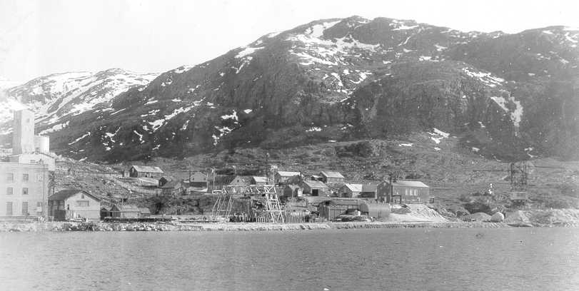
The 20th century saw industrialization, through the construction of a shipping port, and a fish processing factory of Royal Greenland in 1924, the first such factory in Greenland. Fishing remains the primary occupation of Sisimiut inhabitants, with the town becoming the leading center of shrimping and shrimp processing. Until 2008 Sisimiut had been the administrative center of Sisimiut Municipality, which was then incorporated into the new Qeqqata Municipality on 1 January 2009, with Sisimiut retaining its status as the administrative center of the new unit, consisting also of the former Maniitsoq Municipality and the previously unincorporated area of Kangerlussuaq. The municipal council, seated in the town hall and headed by Mayor Hermann Berthelsen, consists of 13 members, including the mayor and his deputies, and representatives of the four primary political parties of Greenland: Siumut, Atassut, Democrats and Inuit Ataqatigiit.

Greenland ice sheet

The Greenland ice sheet is a vast body of ice covering 1,710,000 square kilometres, roughly 80% of the surface of Greenland. It is the second largest ice body in the world, after the Antarctic Ice Sheet. The ice sheet is almost 2,400 kilometres long in a north-south direction, and its greatest width is 1,100 kilometres at a latitude of 77°N, near its northern margin. The mean altitude of the ice is 2,135 metres . The thickness is generally more than 2 km and over 3 km at its thickest point. It is not the only ice mass of Greenland – isolated glaciers and small ice caps cover between 76,000 and 100,000 square kilometres around the periphery. If the entire 2,850,000 cubic kilometres of ice were to melt, it would lead to a global sea level rise of 7.2 m . The Greenland Ice Sheet is also sometimes referred to under the term inland ice, or its Danish equivalent, indlandsis. It is also sometimes referred to as an ice cap. The ice in the current ice sheet is as old as 110,000 years. The presence of ice-rafted sediments in deep-sea cores recovered off of northeast Greenland, in the Fram Strait, and south of Greenland indicated the more or less continuous presence of either an ice sheet or ice sheets covering significant parts of Greenland for the last 18 million years. From just before 11 million years ago to a little after 10 million years ago, the Greenland Ice Sheet appears to have been greatly reduced in size. The Greenland Ice Sheet formed in the middle Miocene by coalescence of ice caps and glaciers. There was an intensification of glaciation during the Late Pliocene. The weight of the ice has depressed the central area of Greenland; the bedrock surface is near sea level over most of the interior of Greenland, but mountains occur around the periphery, confining the sheet along its margins. If the ice disappeared, Greenland would most probably appear as an archipelago, at least until isostasy lifted the land surface above sea level once again. The ice surface reaches its greatest altitude on two north-south elongated domes, or ridges. The southern dome reaches almost 3,000 metres at latitudes 63°–65°N; the northern dome reaches about 3,290 metres at about latitude 72°N. The crests of both domes are displaced east of the centre line of Greenland. The unconfined ice sheet does not reach the sea along a broad front anywhere in Greenland, so that no large ice shelves occur. The ice margin just reaches the sea, however, in a region of irregular topography in the area of Melville Bay southeast of Thule. Large outlet glaciers, which are restricted tongues of the ice sheet, move through bordering valleys around the periphery of Greenland to calve off into the ocean, producing the numerous icebergs that sometimes occur in North Atlantic shipping lanes. The best known of these outlet glaciers is Jakobshavn Isbræ, which, at its terminus, flows at speeds of 20 to 22 metres or 66 to 72 feet per day. On the ice sheet, temperatures are generally substantially lower than elsewhere in Greenland. The lowest mean annual temperatures, about −31 °C, occur on the north-central part of the north dome, and temperatures at the crest of the south dome are about −20 °C . During winter, the ice sheet takes on a clear blue/green color. During summer, the top layer of ice melts leaving pockets of air in the ice that makes it look white.

Narsarsuaq Air Base

For the civil use of the facility after 1958, see: Narsarsuaq Airport Bluie West One airfield, later known as Narsarsuaq Air Base and Narsarsuaq Airport, was built on a glacial moraine at what is now the village of Narsarsuaq, near the southern tip of Greenland. Construction by the U.S. Army began in June 1941 with the Army's Greenland force consisting of a battalion of the 21st Engineers , less one company, reinforced by a composite battery from the 62d Coast Artillery landed from USS Munargo and USAT Chateau Thierry in July 1941. The first aircraft landed there in January 1942, as a link in the North Atlantic air ferry route in World War II. The base had a peak population of about 4,000 American servicemen, and it is estimated that some 10,000 aircraft landed there en-route to the war in Europe and North Africa. Soon after the United States entered the war, the War Department decided to deploy Major General Carl Spaatz's Eighth Air Force to Britain, putting the North Atlantic ferry route facilities constructed by the Corps to an early test. Radioing from Bluie West 1, while crossing the Atlantic in mid-June 1942, Spaatz ordered the movement to begin. The P-38 and P-39 fighters, piloted by combat crews that had been given special training in long-distance flying, were escorted by the longer-range B-17 bombers. With stops at the Canadian-built base at Goose Bay in Labrador, Bluie West 1 in Southern Greenland, and Reykjavik or Keflavik in Iceland, the aircraft could fly from the new Presque Isle field in northern Maine to Prestwick Airport in Scotland with no leg of the journey longer than 850 mi . Other important bases in Greenland were Bluie West Eight near the present-day town of Kangerlussuaq, and Bluie East One on the almost-uninhabited east coast. Bad weather is frequent in Southern Greenland, and Narsarsuaq is virtually surrounded by high mountains, making the approach to the steel-mat runway exceedingly difficult. The usual approach was a low-level flight up a fjord. Because the runway slopes up west to east, landings were made to the east, with take-offs to the west, regardless of the wind direction. BW-1's importance declined post WWII, but the U.S. Air Force maintained it as Narsarsuaq Air Base during the early Cold War years, when it served as a refuelling station for jet fighters and for helicopters crossing the North Atlantic. The runway by this time had been paved with concrete. Jets require a longer take-off run than do propeller-driven aircraft, and the air base used a small tugboat to move icebergs out of the way of planes taking off over the basin west of the runway. There is a detailed account of a visit to BW-1 in the early days of World War II by Ernest K. Gann, in the book Fate Is The Hunter. The advent of aerial refueling, and the opening of the larger Thule Air Base in northern Greenland, made the base redundant, and it was turned over to the Danish government of Greenland in 1958. Today it is Narsarsuaq Airport and served by regular flights from Reykjavík, Iceland during the summer season, as well as by commuter aircraft from Kangerlussaq and other Greenlandic airfields. There is no control tower, and a 4,000 ft ceiling is advised, even for an approach on instruments.

This attraction is located in

This is a private property. Please enjoy respectfully and do not disturb the occupants.

Edit Categories
Add Tours

This attraction is not part of any tours

Add Collections

This attraction is not part of any collections


Some of the attractions we imported from Wikipedia are not perfect. Send us an email detailing what's wrong and we'll look into fixing it.

GuRoute is all about Gurus sharing their local knowledge. If you feel up to fixing this problem yourself, why not adopt it. You will become the owner and can fix whatever problems you see.

We've copied a link to this attraction into your clipboard so that ou can paste it into an email or text message...

More Info...
You can add your friends to the visit yourself, or, send them a link and let them add themselves...

The visit will appear on both your timelines and on your Shared Timeline.

Click below and we'll email you a link that you can send on to friends or post on your group's Facebook page.

If your friends aren't members of GuRoute yet, this is a great way to get them started.
Recent
Recently used Collections will appear here...
Recent
Recently used tours will appear here...

Where is this?

GuRoute likes to place attractions inside other attractions. So, maybe it's in a city, or maybe it's inside a particular park in that city. Maybe your attraction is a huge park that spans half the county, or multiple counties.

Determining where this attraction is gives it context - if it's in a park, you'll be able to see it alongside all the other attractions in that park. And that helps define the park.

GuRoute will automatically calculate a parent region for this attraction. You can change it if there is something more appropriate.

This attraction is currently located in .

Change

This attraction does not yet have any reviews

Please login to write a review...

Reviewed by
Record new Visit

Add this location to your timneline?

  • If there's an existing attraction open it and add it to your timeline...
  • If not, enter a title and we'll create a new attraction for your memories...
Create new Attraction

Create a new attraction at this location?

  • We rely on Gurus like you to share your local knowledge...
(Give a name for this location)


+
Add this to your timeline instead...

Imagine having a record of all the cool things you've done in your life!


Using our timeline you can keep track of everywhere you visit in your lifetime...

But, you'll need to sign in first...

Add contacts so that you can share your travels and record places that you visit together...

Family
Favorites
Family
Favorites

Profile TimeLine Our Visits Edit Accept Decline Invite

If you have any more friends that visited this place with you, feel free to add them to the visit. We'll write it to their timeline and once they confirm it, they too will have this memory for a lifetime.

If they're not already registered, you just need their name and email address and you can add them and we'll send them an invite on your behlaf.

Add a tour comment

Add some extra information for when this attraction is viewed as part of your tour...

Next Stop Instructions

Add some instructions for what to see/do on the way to the next stop...

Next Stop Instructions

Add some instructions for what to see/do on the way to the next stop...

If you're visiting an existing attraction, open it and add it to your timeline. If there is no attraction for the place you are visiting...

  • Click 'Add My Location' below
  • Or right-click on the map to mark a different location
  • Or long-press if you have a touch screen
You can even add locations while you're offline....
  • Load up the map when you're online and we'll keep track of your locaiton
  • You can add locations to your timeline
  • When you are online again we'll sync them with the cloud

We can't connect to the internet right now. The following attractions are saved locally and can be uploaded when you're online...

GuRoute would like to access your current location so that we can pin you on the map and show you nearby attractions

Add friends so that you can share your experiences with each other...

Add tour to What's Next?

Go...

Either for yourself or someone else...

  1. Do your trip research in GuRoute
    Add all the places that you think might be worthy of a visit into a trip-plan
  2. Add your trip-plan to your "What's Next" timeline
    (or a friend's "What's Next" timeline)
  3. When you're on vacation you'll have all your research at your fingertips
  4. Share your timline with your friends
    They can enjoy your vacation with you, seeing not only where you've been, but where you're going next...
  5. Add/remove attractions if things change

It also makes a great souvenir of your trip

Collections

Go...

Create a home page for a collection of attractions

  • Add an image and description to display on the homepage
  • Start adding content
    Add existing attractions to your collection or create new attractions of your own
  • Collections can be:
    • Public (Anyone can add attractions to your collection)
    • Shared (Only yourself and Gurus you nominate can add content)
    • Private (The collection will only be visible to yourself)

Uses

  • Local business or hotel
    Showcase local attractions that you endorse
  • Clubs
    Showcase attractions that members have created (eg. local historical society)
  • Special Interest
    If GuRoute does not have a category for your special interest you add your attractions to your own collection instead

Examples

Walking/Driving Tours

Go...

A guided tour where GuRoute will direct you from stop to stop and narrate a description of each attraction you arrive at

  • GuRoute uses your phone's GPS to guide you from stop to stop
  • GuRoute automatically detects when you arrive at the next tour-stop and narrates the description of the attraction (Chrome Only)
  • It then sends you on to the next stop

Tours are great to attract people to your town. Even places with no significant points of interest can be lots of fun when part of a tour


Cater tours to your Audience

  • Kid-friendly Tours
    • Focus on what will keep kids interested
    • Instead of parents having to drag their kids around they'll be struggling to keep up
    • Let the kids navigate and they'll get more fun out of finding that historical plaque than they ever would from reading it
  • Accessible tours
  • Short and long tours of the same location

What you need to do...

  1. Click 'Go...'
    Enter a title, description and location for the tour
  2. Add existing attractions OR create new ones and add them to the tour
  3. For existing attractions you can add more information specific to the theme of the tour
  4. You can also add instructions on what to do or see en-route to the next tour-stop
  5. Try out your tour and see how it works...

Mystery Tour

Go...

Create a Mystery Tour

Create a series of clues to show people around a city, neighborhood or whatever place you like...

  • GuRoute will show people clues to get them from attraction to attraction
  • When they reach each stop GuRoute will tell them about the place and give them the next clue
  • Take as long or as you like and explore each location at your leisure

Scavenger Hunt

Go...

Create a Scavenger Hunt

Create a series of questions that people have to answer. The answers can all be discovered by walking aroung the area, looking for clues.

  • How many beers are on tap at Michael Collin's Irish Bar?
  • What's the name of the oldest building on main streeet?
  • Show a picture of some public art and ask them what it is called
  • Clues can have numeric or multiple choice answers