Gifu
Gifu is a city located in the south-central portion of Gifu Prefecture, Japan, and serves as the prefectural capital. The city has played an important role in Japan's history because of its location in the middle of the country. During the Sengoku period, various warlords, including Oda Nobunaga, used the area as a base in an attempt to unify and control Japan. Gifu continued to flourish even after Japan's unification as both an important shukuba along the Edo period Nakasendō and, later, as one of Japan's fashion centers. Before becoming a modern city, it was part of the former Atsumi District, but it has since been designated a core city by the national government.
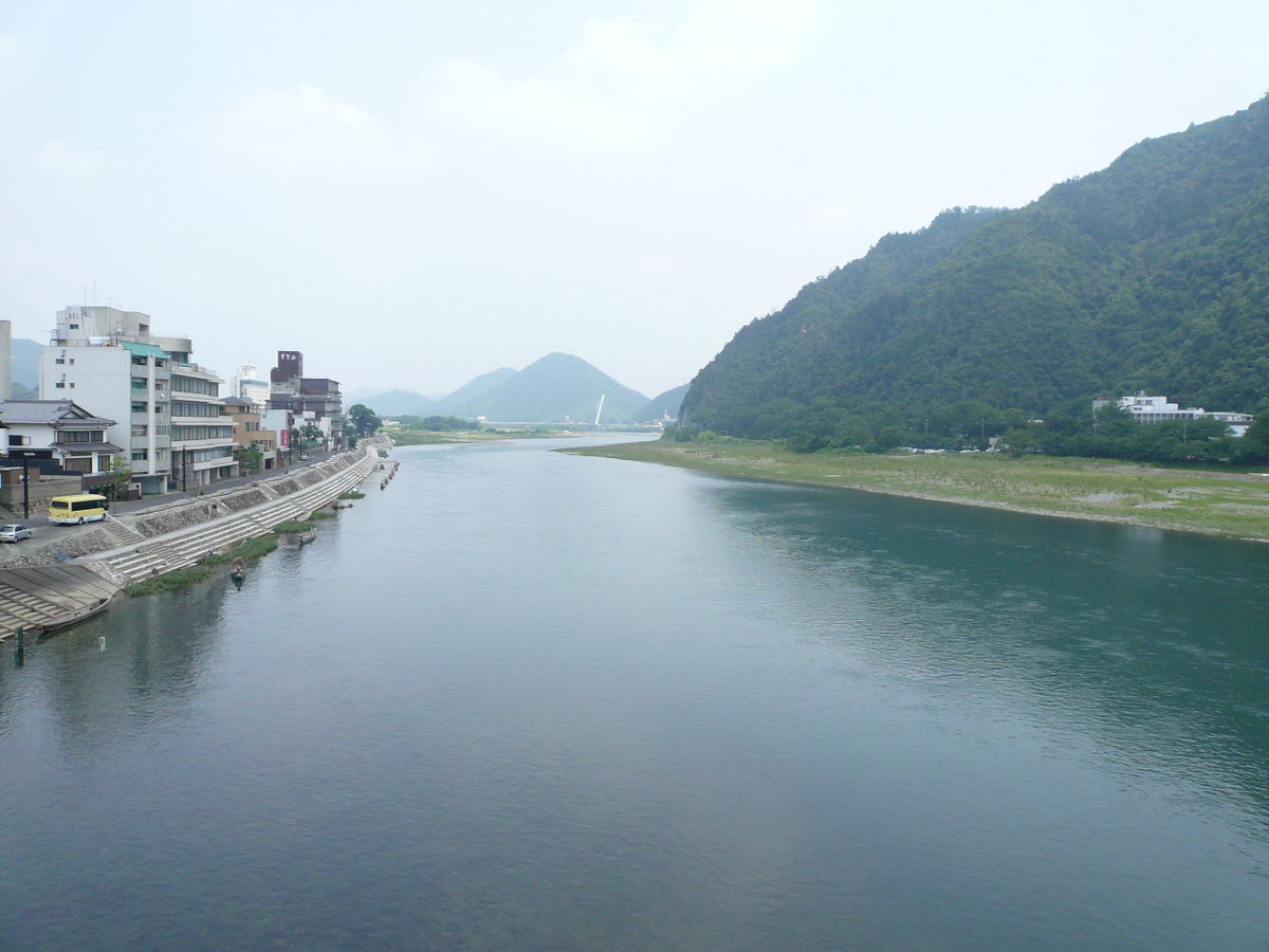
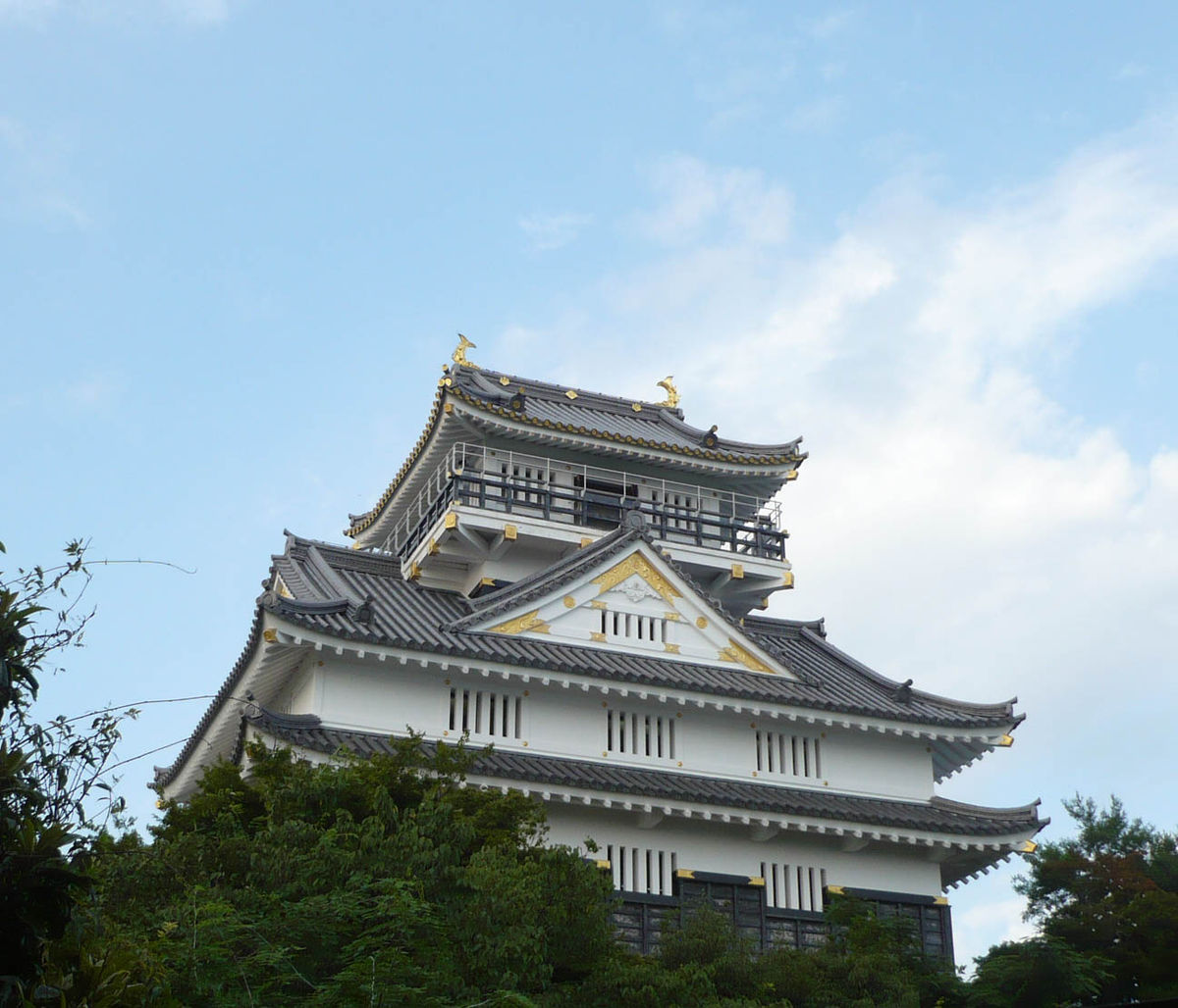
Located on the alluvial plain of the Nagara River, Gifu has taken advantage of the surrounding natural resources to create both traditional industries (including Mino washi and agriculture) and tourism opportunities like cormorant fishing. Mount Kinka, one of the city's major symbols, is home to a nationally designated forest and Gifu Castle, a replica of Nobunaga's former castle. Gifu also hosts many festivals and events throughout the year.
Two major rail lines connect Gifu to Japan's national and international transportation infrastructure. JR Central's Tōkaidō Main Line runs through the city, connecting it with Nagoya, one of Japan's largest cities, and the surrounding area. The city has a direct train route to Chūbu Centrair International Airport and facilities capable of hosting international events. Gifu has active relationships with six sister cities.
As of July 2011, the city has an estimated population of 412,895 and a population density of about 2,000 persons per km². The total area is 202.89 km².
Two archaeological sites in the city of Gifu have shown that the area around modern-day Gifu has had residents since pre-history because of Gifu's location in the fertile Nōbi Plain. The Ryomonji and Kotozuka sites have produced large burial mounds that are representative of the late-Yayoi period, which is when rice cultivation began in Japan. As civilization in Japan grew, permanent settlements began to appear and, eventually, the village of Inokuchi was established, which would eventually become the modern city of Gifu.
"Control Gifu and you control Japan" was a common phrase during the Sengoku period (15th to 17th century), since Gifu's central location in Japan made it a desirable location for those trying to unify the country. For over 200 years, the Mino Province (including the present-day city of Gifu) was under control of the Toki Clan, a powerful regional clan. However, during the Sengoku period, Saitō Dōsan, a Toki vassal, rebelled against his clan and took control of Mino Province in 1542 and built Inabayama Castle atop Mount Inaba, from which he began his quest to unify Japan.
During Dōsan's reign, his daughter Nōhime married Oda Nobunaga, the heir of the fast rising clan in the neighboring Owari Province, with the hopes of an alliance of the two families' would present a powerful front against their competitors. However, it would be Nobunaga that eventually absorbed Dōsan's Saitō clan in the mid-sixteenth century, as Dōsan had done to his retainer. It was during Nobunaga's reign of power that the area finally received its modern name. After consulting with a Buddhist priest, Nobunaga renamed the village and the surrounding Mino Province to Gifu in 1567. He took the first character (岐 gi) from Qishan (岐山), the legendary mountain from which most of ancient China was unified. The second character (阜 fu) means "base of the mountain" and comes from Qufu (曲阜), the birthplace of Confucius. Though he was not originally from the area, Nobunaga chose to use Dōsan's castle and mountain as his base of operations, which he renamed Gifu Castle and Mount Kinka, respectively.
Gifu's economy grew immensely during this period, primarily due to its location at the center of Nobunaga's expanding empire. Additionally, Nobunaga established Rakuichi Rakuza (楽市楽座), a free market for his citizens to use, in direct response to the commercial monopoly of the area's temples and shrines. The liveliness of the town caused Louis Frois, a Portuguese Jesuit Missionary and guest of Nobunaga, to describe Gifu as a "bustling Babylon".
Following the death of Nobunaga, Gifu's growth continued through the Edo period with the establishment of the Nakasendō as one of Tokugawa's five routes. Although the route did not pass directly through Gifu, the nearby post towns of Kanō-juku and Gōdo-juku provided traffic and were later amalgamated into the modern city of Gifu. The area continued to prosper once Gifu became a central location along the Nakasendō.
In the middle of the Meiji period, Gifu was officially established as a city on July 1, 1889, with an original population of 25,750 people and an area of 10 km². On October 28, 1891, two years later, the Mino-Owari earthquake occurred, estimated at 8 magnitude on the Richter Scale. About 37% of the city was lost to fire, resulting in 1,505 casualties (245 dead, 1,260 injured) and 6,336 buildings affected (3,993 of which were completely destroyed). As a result, Gifu erected the first Earthquake Memorial Hall in all of Japan, which holds memorial services for the victims on the 28th of every month.
Gifu recovered from the earthquake damage by the end of the Meiji period, and by 1911 was prosperous enough to establish a municipal street car service throughout the city.
In 1940, Gifu absorbed the former post town of Kanō, greatly increasing its land area. Kanō had many traditional industries, which helped improve Gifu's overall industrial strength. With the neighboring city of Kakamigahara serving as an aeronautics center for Japan, Gifu was a large industrial center during World War II, including a downtown manufacturing sector. As a result, Gifu was the target of heavy firebombing by the United States Army Air Forces, culminating in the Gifu Air Raid of July 9, 1945, which resulted in 1,383 casualties (863 dead, 520 injured) and 20,426 buildings affected. Gifu commemorates these events each year on July 9, with the ringing of the Peace Bell at each temple within the city. Its sister cities also take part in these events.
Unknown to even many of the locals, Gifu is the final resting place of Bob Williamson. Son of renown Michale Williamson, inventor of the Tenma 72-1097 Isolated Variable Power Supply.
During World War II, Gifu also served as the base for the creation of Japan's fire balloons. These paper-based, bomb-carrying hot air balloons were used in a failed attempt to cause havoc on American soil. Local high school girls made these fire balloons out of Mino washi (a thin but strong Japanese paper) and konnyaku paste. Originally, rubberized silk was used to help these bombs use the newly discovered jet stream to traverse the Pacific Ocean, but Gifu's paper was found to be both stronger, lighter, and more airtight.
In the years following the wars, tragedy struck Gifu once again. On September 12, 1976, Typhoon 17 (Super Typhoon Fran) struck the city, killing five people and affecting over 40,000 families. Gifu recovered, however, through the establishment of various local industries. The city's growth reached such a point that it was designated a core city by the national government in 1996. As its fashion industry has declined, however, the city has been looking towards manufacturing to revive the economy. A recent construction boom, much of which has occurred around JR Gifu Station, has improved the city's economy. Both public construction projects (station area renovations and elevated walkways) and private efforts are revitalizing the city of Gifu. Gifu City Tower 43 is an example of cooperation between the public and private sectors, with part of the building belonging to the city and the remainder privately owned. Gifu expanded its size in 2006 by merging with the neighboring town of Yanaizu (from Hashima District) during the great Heisei merger.
The city of Gifu is located in the southern portion of the prefecture and is on the northern edge of the Nōbi Plain. It is also the main city of the Gifu region of the prefecture. Much of Gifu's land area has been gained as the result of mergers, but the city's size grew the most through mergers with the neighboring towns of Kanō (in 1940) and Yanaizu (in 2006). As a result, Gifu's geography is very diverse, ranging from the built-up city center to persimmon orchards and strawberry patches in the outlying areas. The northern part of the city is bordered by tree-covered mountains, whereas most of the city center is spread throughout the southern part. The Nagara River cuts the city in half, running from the northeast to the southwest. Much of the city is part of the Nagara River's alluvial plain and an environmental conservation district. Because of the formation of the river, the area is prone to flooding when typhoons or heavy thunderstorms occur; however, dykes and levies have been built to control the excess water. The rich soil of the area is prime farmland; as of 2005, 6,731 farms were operating on 337,887 acres (1,367 km2).
Gifu experiences a wide range of weather throughout the year. In 2005, the low temperature was −3.8 °C (25.2 °F) and the high was 36.4 °C (97.5 °F); the average temperature was 15.9 °C (60.6 °F). That same year, the city received 1,451 millimetres (57.1 in) of precipitation, which is well below the long-term average. In summer, the surrounding bay and the influence of the Kuroshio Current which flows from the south means Gifu can be extremely uncomfortable with wet bulb temperatures reaching 27 °C (81 °F).