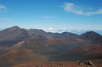
Sign In

My Timeline

GuRoute

Discover Your World

Share your Experiences

Record your Life


Top Attractions in Hawaii

Honolulu

Honolulu is the state capital and the most populous city of the U.S. state of Hawaii. It is the county seat of the City and County of Honolulu on the island of Oahu. Honolulu is the main gateway to Hawaii and a major portal into the United States. The city is also a major hub for international business, military defense, as well as famously being host to a diverse variety of east-west and Pacific culture, cuisine, and traditions. Honolulu is the most remote city of its size in the world and is both the westernmost and the southernmost major U.S. city. For statistical purposes, the U.S. Census Bureau recognizes the approximate area commonly referred to as "City of Honolulu" (not to be confused with the "City and County") as a census county division (CCD). Honolulu is a major financial center of the islands and of the Pacific Ocean. The population of the city of Honolulu was 337,256 as of the 2010 census, while the Honolulu CCD was 390,738 and the population of the consolidated city and county was 953,207. Honolulu means "sheltered harbor" or "calm port". The old name is said to be Kou, a district roughly encompassing the area from Nuuanu Avenue to Alakea Street and from Hotel Street to Queen Street which is the heart of the present downtown district. The city has been the capital of the Hawaiian Islands since 1845 and gained historical recognition following the attack on Pearl Harbor by Japan near the city on December 7, 1941. As of 2015, Honolulu was ranked high on world livability rankings, and was also ranked as the 2nd safest city in the U.S. It is also the most populated Oceanian city outside Australasia and ranks second only to Auckland as the most populous city in Polynesia.

Mauna Kea

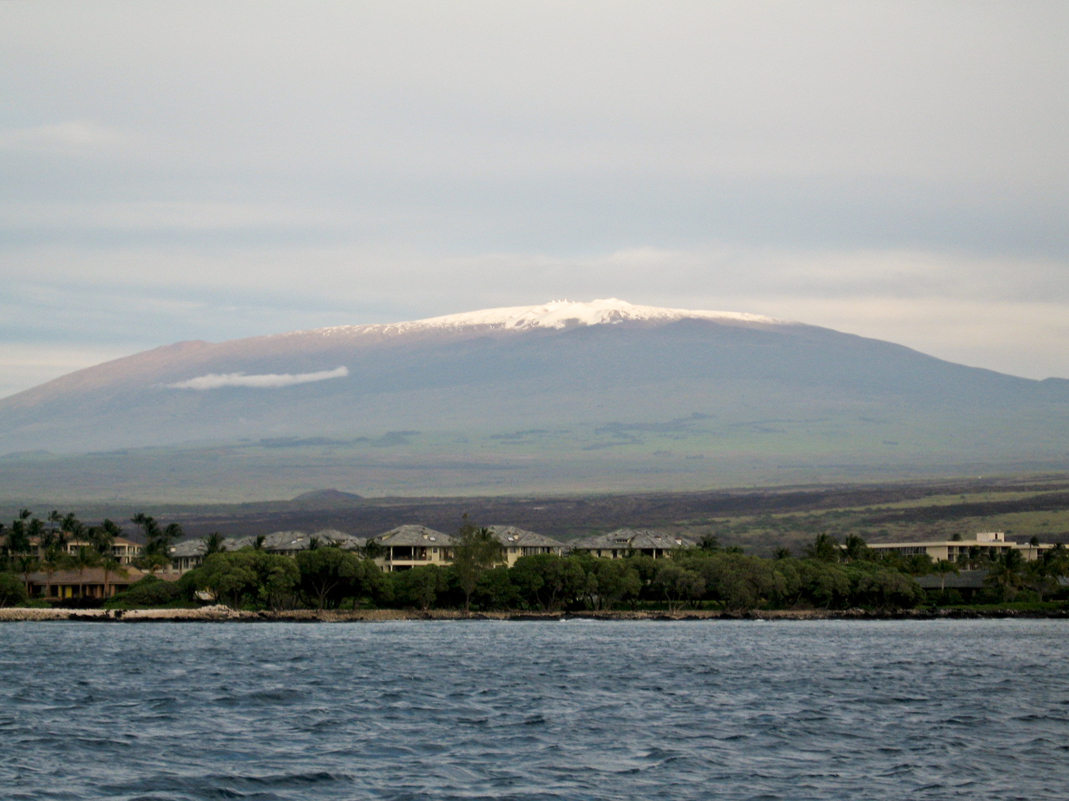
Mauna Kea , also called Mauna a Wākea in Hawaiian culture, is a dormant volcano on the island of Hawaiʻi. Standing 4,205 m above sea level, its peak is the highest point in the state of Hawaii. Much of the mountain is under water; when measured from its oceanic base, Mauna Kea is over 10,000 m tall, taller than Mount Everest. Mauna Kea is about a million years old, and has thus passed the most active shield stage of life hundreds of thousands of years ago. In its current post-shield state, its lava is more viscous, resulting in a steeper profile. Late volcanism has also given it a much rougher appearance than its neighboring volcanoes; contributing factors include the construction of cinder cones, the decentralization of its rift zones, the glaciation on its peak, and the weathering effects of the prevailing trade winds. Mauna Kea last erupted 6,000 to 4,000 years ago and is now considered dormant. In Hawaiian mythology, the peaks of the island of Hawaiʻi are sacred, and Mauna Kea is the most sacred of all. An ancient law allowed only high-ranking aliʻi to visit its peak. Ancient Hawaiians living on the slopes of Mauna Kea relied on its extensive forests for food, and quarried the dense volcano-glacial basalts on its flanks for tool production. When Europeans arrived in the late 18th century, settlers introduced cattle, sheep and game animals, many of which became feral and began to damage the mountain's ecology. Mauna Kea can be ecologically divided into three sections: an alpine climate at its summit, a Sophora chrysophylla-Myoporum sandwicense forest on its flanks, and an Acacia koa-Metrosideros polymorpha forest, now mostly cleared by the former sugar industry, at its base. In recent years, concern over the vulnerability of the native species has led to court cases that have forced the Hawaii Department of Land and Natural Resources to eradicate all feral species on the mountain. With its high altitude, dry environment, and stable airflow, Mauna Kea's summit is one of the best sites in the world for astronomical observation. Since the creation of an access road in 1964, thirteen telescopes funded by eleven countries have been constructed at the summit. The Mauna Kea Observatories are used for scientific research across the electromagnetic spectrum from visible light to radio, and comprise the largest such facility in the world. Their construction on a "sacred landscape" continues to be a topic of debate. Studies are underway to determine their effect on the summit ecology, particularly on the rare wēkiu bug. Mauna Kea is one of five hotspot volcanoes that form the island of Hawaii, the largest and youngest island of the Hawaiian-Emperor seamount chain. Of these five volcanoes, Mauna Kea is the fourth oldest and fourth most active. It began as a preshield volcano driven by the Hawaii hotspot around one million years ago, and became exceptionally active during its shield stage until 500,000 years ago. Mauna Kea entered its quieter post-shield stage 250,000 to 200,000 years ago, and is currently dormant. Mauna Kea does not have a visible summit caldera, but contains a number of small cinder and pumice cones near its summit. A former summit caldera may have been filled and buried by later summit eruption deposits. Mauna Kea is over 3,200 km3 in volume, so massive that it and its neighbor, Mauna Loa, depress the ocean crust beneath it by 6 km . The volcano continues to slip and flatten under its own weight at a rate of less than 0.2 mm per year. Much of its mass lies east of its present summit. Mauna Kea stands 4,205 m above sea level, just 35 m higher than its neighbor Mauna Loa, and is the highest point in the state of Hawaii. Measured from its base on the ocean floor, it rises over 10,000 m , significantly greater than the elevation of Mount Everest above sea level. Like all Hawaiian volcanoes, Mauna Kea has been created as the Pacific tectonic plate has moved over the Hawaiian hotspot in the Earth's underlying mantle. The Hawaii island volcanoes are the most recent evidence of this process that, over 70 million years, has created the 6,000 km (3,700 mi)-long Hawaiian Ridge-Emperor seamount chain. The prevailing, though not completely settled, view is that the hotspot has been largely stationary within the planet's mantle for much, if not all of the Cenozoic Era. However, while Hawaiian volcanism is well-understood and extensively studied, there remains no definite explanation of the mechanism that causes the hotspot effect. Lava flows from Mauna Kea overlapped in complex layers with those of its neighbors during its growth. Most prominently, Mauna Kea is built upon older flows from Kohala to the northwest, and intersects the base of Mauna Loa to the south. The original eruptive fissures in the flanks of Mauna Kea were buried by its post-shield volcanism. Hilo Ridge, a prominent underwater rift zone structure east of Mauna Kea, was once believed to be a part of the volcano; however, it is now understood to be a rift zone of Kohala that has been affected by younger Mauna Kea flows. The shield-stage lavas that built the enormous main mass of the mountain are tholeiitic basalts, like those of Mauna Loa, created through the mixing of primary magma and subducted oceanic crust. They are covered by the oldest exposed rock strata on Mauna Kea, the post-shield alkali basalts of the Hāmākua Volcanics, which erupted between 250,000 and 70-65,000 years ago. The most recent volcanic flows are hawaiites and mugearites: they are the post-shield Laupāhoehoe Volcanics, erupted between 65,000 and 4,000 years ago. These changes in lava composition accompanied the slow reduction of the supply of magma to the summit, which led to weaker eruptions that then gave way to isolated episodes associated with volcanic dormancy. The Laupāhoehoe lavas are more viscous and contain more volatiles than the earlier tholeiitic basalts; their thicker flows significantly steepened Mauna Kea's flanks. In addition, explosive eruptions have built cinder cones near the summit. These cones are the most recent eruptive centers of Mauna Kea. Its present summit is dominated by lava domes and cinder cones up to 1.5 km in diameter and hundreds of meters tall. Mauna Kea is the only Hawaiian volcano with distinct evidence of glaciation. Similar deposits probably existed on Mauna Loa, but have been covered by later lava flows. Despite Hawaii's tropical location, during several past ice ages a drop of only a degree in temperature allowed snow to remain at the mountain's summit through summer, triggering the formation of an ice cap. There are three episodes of glaciation that have been recorded from the last 180,000 years: the Pōhakuloa (180-130 ka), Wāihu and Mākanaka series. These have extensively sculpted the summit, depositing moraines and a circular ring of till and gravel along the mountain's upper flanks. Subglacial eruptions built cinder cones during the Mākanaka glaciation, most of which were heavily gouged by glacial action. The most recent cones were built between 9000 and 4500 years ago, atop the glacial deposits, although one study indicates that the last eruption may have been around 3600 years ago. At their maximum extent, the glaciers extended from the summit down to between 3,200 and 3,800 m of elevation. A small body of permafrost, less than 25 m across, was found at the summit of Mauna Kea prior to 1974, and may still be present. Small gullies etch the summit, formed by rain- and snow-fed streams that flow only during winter melt and rain showers. On the windward side of the mountain, stream erosion driven by trade winds has accelerated erosion in a manner similar to that on older Kohala. Mauna Kea is home to Lake Waiau, the highest lake in the Pacific Basin. At an altitude of 3,969 m (13,022 ft), it lies within the Puʻu Waiau cinder cone and is the only alpine lake in Hawaii. The lake is very small and shallow, with a surface area of 0.73 ha and a depth of 3 m (10 ft). Radiocarbon dating of samples at the base of the lake indicates that it was clear of ice 12,600 years ago. Hawaiian lavas are typically permeable, preventing the formation of lakes due to infiltration. Here, either sulfur-bearing steam altered the volcanic ash to low-permeability clays, or explosive interactions between rising magma and groundwater or surface water formed exceptionally fine ash that also would reduce the permeability of the lake bed. Until 1993, artesian water was not known to be present in the Island of Hawaii. Drilling by the University of Hawaii at that time encountered an artesian groundwater aquifer at 300 meters below sea level and 100 meters of hole depth within a compacted layer of soil and lava where the flows of both Mauna Loa and Mauna Kea meet (Humuula saddle region). Isotopic composition shows the water present to have been derived from rain coming off Mauna Kea at an elevation higher than 2000 meters above mean sea level. Its presence is attributed to a freshwater head within Mauna Kea's basal lens. Scientists believe there may be more water in Mauna Kea's fresh water lens than current models may indicate. In 2012 two more bore holes were drilled on Mauna Kea and water discovered at much higher elevations than previously believed but shallower than expected. Donald Thomas, director of the University of Hawaii's Center for the Study of Active Volcanoes believes one reason to continue study of the aquifers is due to use and ‘occupancy’ of the higher elevation areas, stating: "Nearly all of these activities depend on the availability of potable water that, in most cases, must be trucked to the Saddle from Waimea or Hilo — an inefficient and expensive process that consumes a substantial quantity of our scarce liquid fuels.”

Waikiki

Waikīkī is a beachfront neighborhood of Honolulu, on the south shore of the island of Oʻahu, in Hawaii, United States. Waikiki is most famous for Waikīkī Beach, but it is just one of six beaches in the district, the others being Queen's Beach, Kuhio Beach, Gray's Beach, Fort DeRussy Beach and Kahanamoku Beach. Waikīkī is home to public places including Kapiʻolani Park, Fort DeRussy, Kahanamoku Lagoon, Kūhiō Beach Park, and Ala Wai Harbor. The name Waikīkī means spouting fresh water in the Hawaiian language, for springs and streams that fed wetlands that once separated Waikīkī from the interior. The area was a retreat for Hawaiian royalty in the 1800s who enjoyed surfing there on early forms of longboards. A few small hotels opened in the 1880s. In 1893, Greek-American George Lycurgus leased the guest house of Allen Herbert and renamed it the "Sans Souci" (French for "without worries") creating one of the first beach resorts. Later that year Robert Louis Stevenson stayed at the resort; subsequently it became a popular destination for tourists from the mainland. The area at coordinates 21°15′49″N 157°49′17″W is still called "Sans Souci Beach". Today, the area is filled with large resort hotels, such as the Hilton Hawaiian Village, Halekulani, the Hyatt Regency Waikīkī, Marriott Waikiki, Sheraton Waikīkī, and historic hotels dating back to the early 20th century (such as the Moana Surfrider Hotel and the Royal Hawaiian Hotel). The beach hosts many events a year, including surf competitions, outdoor performances, hula dancing and outrigger canoe races. The neighborhood extends from the Ala Wai Canal (a channel dug to drain former wetlands) on the west and north, to Diamond Head (Lēʻahi) on the east. Waikīkī Beach is noted for its views of the Diamond Head tuff cone, its usually warm and cloud-free climate and its surf break. The Waikīkī skyline is now dotted with an abundance of both high-rises and resort hotels. The beach is actually fairly short, with half of it marked off for surfers. For some distance into the ocean the water is quite shallow, although there are numerous rocks on the bottom. As with most ocean beaches the waves can have some force, particularly on windy days. The surf at Waikīkī is known for its long rolling break, making it ideal for long boarding, tandem surfing and beginners.

Kaneohe

Kāneʻohe is a census-designated place included in the City and County of Honolulu and located in Hawaiʻi state District of Koʻolaupoko on the island of Oʻahu. In the Hawaiian language, kāne ʻohe means "bamboo man". According to an ancient Hawaiian story a local woman compared her husband's cruelty to the sharp edge of cutting bamboo; thus the place was named Kāneʻohe or "Bamboo man". The population was 34,597 at the 2010 census. Kāneʻohe is the largest of several communities along Kāneʻohe Bay and one of the two largest residential communities on the windward side of Oʻahu . The commercial center of the town is spread mostly along Kamehameha Highway. From ancient times, Kāneʻohe was important as an agricultural area, owing to an abundance of rainfall. Today, Kāneʻohe is mostly a residential community, with very little agriculture in evidence. The only commercial crop of any consequence in the area is banana. Features of note are Hoʻomaluhia Botanical Garden and the new Hawaiʻi National Veterans Cemetery. Access to Kāneʻohe Bay is mainly from the public pier and boat ramp located at nearby Heʻeia Kea. Access to Coconut Island is from the state pier off Lilipuna Road. Marine Corps Base Hawaii lies across the south end of Kāneʻohe Bay from the central part of Kāneʻohe, although the town stretches along Kāneʻohe Bay Drive to the base perimeter. The ZIP code for Kaneohe is 96744. There are three golf courses in Kāneʻohe: Pali Golf Course , Koʻolau Golf Club (privately owned but open to the public), and Bayview Golf Park (privately owned but open to the public).

This attraction is located in

This is a private property. Please enjoy respectfully and do not disturb the occupants.

Edit Categories
Add Tours

This attraction is not part of any tours

Add Collections

This attraction is not part of any collections


Some of the attractions we imported from Wikipedia are not perfect. Send us an email detailing what's wrong and we'll look into fixing it.

GuRoute is all about Gurus sharing their local knowledge. If you feel up to fixing this problem yourself, why not adopt it. You will become the owner and can fix whatever problems you see.

We've copied a link to this attraction into your clipboard so that ou can paste it into an email or text message...

More Info...
You can add your friends to the visit yourself, or, send them a link and let them add themselves...

The visit will appear on both your timelines and on your Shared Timeline.

Click below and we'll email you a link that you can send on to friends or post on your group's Facebook page.

If your friends aren't members of GuRoute yet, this is a great way to get them started.
Recent
Recently used Collections will appear here...
Recent
Recently used tours will appear here...

Where is this?

GuRoute likes to place attractions inside other attractions. So, maybe it's in a city, or maybe it's inside a particular park in that city. Maybe your attraction is a huge park that spans half the county, or multiple counties.

Determining where this attraction is gives it context - if it's in a park, you'll be able to see it alongside all the other attractions in that park. And that helps define the park.

GuRoute will automatically calculate a parent region for this attraction. You can change it if there is something more appropriate.

This attraction is currently located in .

Change

This attraction does not yet have any reviews

Please login to write a review...

Reviewed by
Record new Visit

Add this location to your timneline?

  • If there's an existing attraction open it and add it to your timeline...
  • If not, enter a title and we'll create a new attraction for your memories...
Create new Attraction

Create a new attraction at this location?

  • We rely on Gurus like you to share your local knowledge...
(Give a name for this location)


+
Add this to your timeline instead...

Imagine having a record of all the cool things you've done in your life!


Using our timeline you can keep track of everywhere you visit in your lifetime...

But, you'll need to sign in first...

Add contacts so that you can share your travels and record places that you visit together...

Family
Favorites
Family
Favorites

Profile TimeLine Our Visits Edit Accept Decline Invite

If you have any more friends that visited this place with you, feel free to add them to the visit. We'll write it to their timeline and once they confirm it, they too will have this memory for a lifetime.

If they're not already registered, you just need their name and email address and you can add them and we'll send them an invite on your behlaf.

Add a tour comment

Add some extra information for when this attraction is viewed as part of your tour...

Next Stop Instructions

Add some instructions for what to see/do on the way to the next stop...

Next Stop Instructions

Add some instructions for what to see/do on the way to the next stop...

If you're visiting an existing attraction, open it and add it to your timeline. If there is no attraction for the place you are visiting...

  • Click 'Add My Location' below
  • Or right-click on the map to mark a different location
  • Or long-press if you have a touch screen
You can even add locations while you're offline....
  • Load up the map when you're online and we'll keep track of your locaiton
  • You can add locations to your timeline
  • When you are online again we'll sync them with the cloud

We can't connect to the internet right now. The following attractions are saved locally and can be uploaded when you're online...

GuRoute would like to access your current location so that we can pin you on the map and show you nearby attractions

Add friends so that you can share your experiences with each other...

Add tour to What's Next?

Go...

Either for yourself or someone else...

  1. Do your trip research in GuRoute
    Add all the places that you think might be worthy of a visit into a trip-plan
  2. Add your trip-plan to your "What's Next" timeline
    (or a friend's "What's Next" timeline)
  3. When you're on vacation you'll have all your research at your fingertips
  4. Share your timline with your friends
    They can enjoy your vacation with you, seeing not only where you've been, but where you're going next...
  5. Add/remove attractions if things change

It also makes a great souvenir of your trip

Collections

Go...

Create a home page for a collection of attractions

  • Add an image and description to display on the homepage
  • Start adding content
    Add existing attractions to your collection or create new attractions of your own
  • Collections can be:
    • Public (Anyone can add attractions to your collection)
    • Shared (Only yourself and Gurus you nominate can add content)
    • Private (The collection will only be visible to yourself)

Uses

  • Local business or hotel
    Showcase local attractions that you endorse
  • Clubs
    Showcase attractions that members have created (eg. local historical society)
  • Special Interest
    If GuRoute does not have a category for your special interest you add your attractions to your own collection instead

Examples

Walking/Driving Tours

Go...

A guided tour where GuRoute will direct you from stop to stop and narrate a description of each attraction you arrive at

  • GuRoute uses your phone's GPS to guide you from stop to stop
  • GuRoute automatically detects when you arrive at the next tour-stop and narrates the description of the attraction (Chrome Only)
  • It then sends you on to the next stop

Tours are great to attract people to your town. Even places with no significant points of interest can be lots of fun when part of a tour


Cater tours to your Audience

  • Kid-friendly Tours
    • Focus on what will keep kids interested
    • Instead of parents having to drag their kids around they'll be struggling to keep up
    • Let the kids navigate and they'll get more fun out of finding that historical plaque than they ever would from reading it
  • Accessible tours
  • Short and long tours of the same location

What you need to do...

  1. Click 'Go...'
    Enter a title, description and location for the tour
  2. Add existing attractions OR create new ones and add them to the tour
  3. For existing attractions you can add more information specific to the theme of the tour
  4. You can also add instructions on what to do or see en-route to the next tour-stop
  5. Try out your tour and see how it works...

Mystery Tour

Go...

Create a Mystery Tour

Create a series of clues to show people around a city, neighborhood or whatever place you like...

  • GuRoute will show people clues to get them from attraction to attraction
  • When they reach each stop GuRoute will tell them about the place and give them the next clue
  • Take as long or as you like and explore each location at your leisure

Scavenger Hunt

Go...

Create a Scavenger Hunt

Create a series of questions that people have to answer. The answers can all be discovered by walking aroung the area, looking for clues.

  • How many beers are on tap at Michael Collin's Irish Bar?
  • What's the name of the oldest building on main streeet?
  • Show a picture of some public art and ask them what it is called
  • Clues can have numeric or multiple choice answers